
Just last month Mountain Legacy team members gathered in Banff with over 150 other mountain researchers for Thinking Mountains 2018 (TM2018). This deeply interdisciplinary summit – the third in a series of conferences started in 2012 – was a standout. Topics ranged from mountain ecology to mapping, from headwater studies to counterculture, from mountain education to monitoring wildlife, and these were just a few of the topics. Indigenous ways of knowing, especially as evidenced in the landscapes of the Canadian Rockies, was a TM2018 feature.
When thinking about mountains it is tough to beat Banff National Park and the Banff Centre as a setting. Examples of conference themes are all around: iconic mountains, celebrated mountain towns, important rivers and lakes, and all the issues, history, and management that go along with accommodating humans, wildlife, and biota in the same location are writ large here.
The weather certainly helped remind participants that life in the mountains can be challenging. Opening day – Tuesday, Oct 2 – saw the entire area from Banff to Calgary digging out from an early blast of winter. 30 to 40 cm of snow fell, causing traffic snarls on roads and cancelling flights in and out of Calgary. Even though some were delayed, TM2018 participants and organizers rolled with the weather and adjusted accordingly. By Thursday the skies were blue and everything was back to normal.

Tuesday on the Bow River. Lots of snow!

Thursday was a bluebird day in the Banff area.
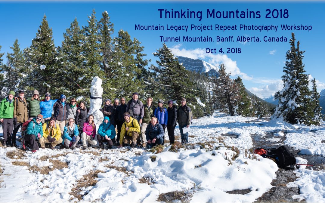
Field Tripping with the Mountain Legacy Project at TM2018
MLP researchers were at TM2018 in force – Eric Higgs, Jill Delaney, Julie Fortin, Rick Arthur, Rob Watt, Kristen Walsh, Mary Sanseverino, and Mike Whitney all attended. The entire team led a repeat photography field trip up Tunnel Mountain. In all, 30+ people met at the base of Tunnel, hiked up to the top on a stunning bluebird afternoon, and attempted to locate images taken in 1888 and 1890 by surveyor James Joseph McArthur when he mapped this area.

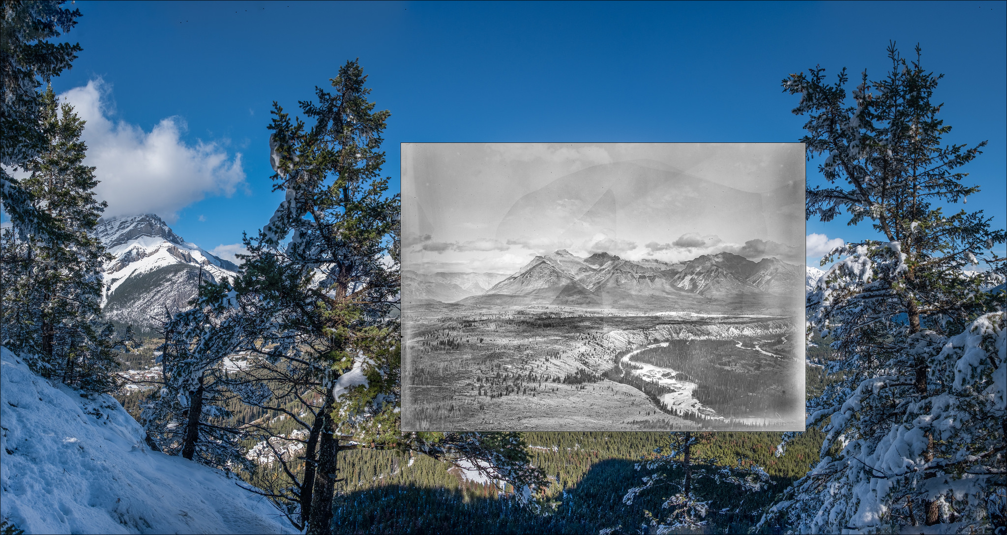
The town of Banff – 130 years ago. Three of the images taken by James McArthur on top of Tunnel Mountain in 1888 and 1890. These images were used to help make some of the first topographic maps in the area.
Click on Tunnel Mountain 1888 and 1890 to view photos taken from this vantage point and used on the field trip.
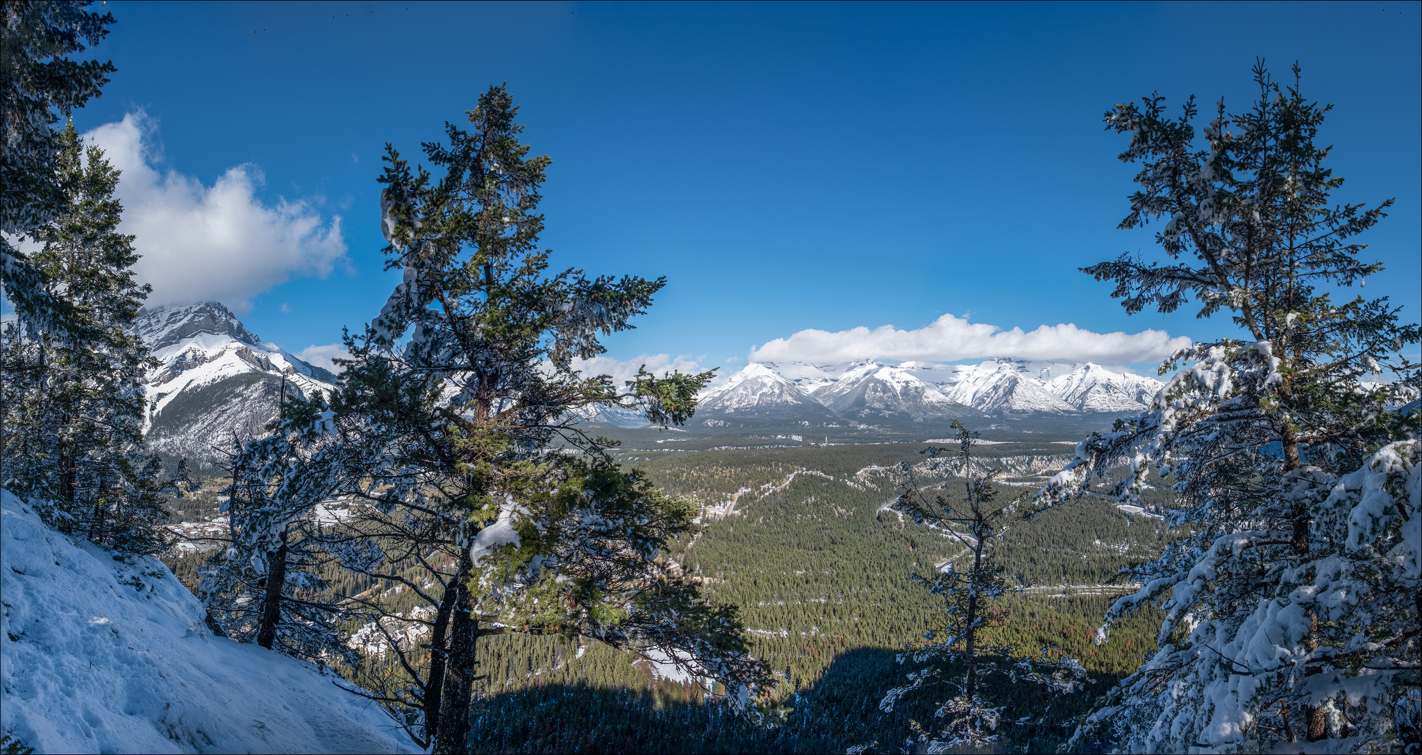
Once on top, MLP members set up two cameras and took participants through the rephotography process. Everyone was encouraged to use their own cameras and/or smartphones too – just to get a taste for how this kind of research might be undertaken. Dan Farr, Director, Biodiversity and Ecosystem Health Sciences at Alberta Environment and Parks, was on the field trip. He repeated one of the shots looking over Banff itself.
Check out Dan’s Twitter Feed, linked in below, to see his repeat of a photo taken 130 years ago by McArthur from the same location. The shots are looking west from Tunnel Mountain across the Bow River Valley; Banff townsite in the foreground. Although not the best photo McArthur ever took (smoke/haze in the air on that day back in 1888) the increase in tree cover is quite noticeable. As well, both modern day and historic photos clearly show how the Bow River valley has been used as a transportation corridor. Increasingly road, rail, and urban infrastructure bisect the valley, an important issue to see and understand, especially when considering that a large amount of wildlife moves regularly through this same space.
Thanks @msanseve and https://t.co/J6agbfb6ua for an excellent field trip last week at @thinkingmtns. Here’s my try at repeating the photo taken 130 yrs ago by JJ McArthur, looking west from Tunnel Mountain across the Bow River Valley; Banff townsite in the foreground. So cool! pic.twitter.com/doHxbcsetH
— Dan Farr (@DanFarrBiota) October 10, 2018
With respect to vegetation the view eastward is, perhaps, more striking. Click on the image below to move between 2018, 1888, and 1890 images. Increased forest cover is evident along the banks of the Bow and over the plateau north (left when looking at the image) of the river. And, when comparing the 1888 and 1890 images, notice how a road now runs along the plateau. This is today’s Tunnel Mountain Road.

A Few Reflections on Thinking Mountains 2018
The feedback from field trip participants has been positive – certainly it was a wonderful day out on Tunnel Mountain with lots of people reflecting on landscape change in the mountains.
As well as the field trip, Mountain Legacy researchers gave a session at the conference itself. Topics covered included a project overview (Eric Higgs, Mountain Legacy PI), the development of photo-topography for map making (Jill Delaney, Library and Archives Canada); evidence of traditional use of fire on the landscape by indigenous people (Rick Arthur); software tools for visualizing change in the images (Mary Sanseverino/Mike Whitney); examples of repeat photography use in ecological modelling in the Willmore Wilderness and the Crowsnest areas of Alberta (Julie Fortin, Landscapes in Motion).
Often with conferences the biggest take-aways are not from the formal sessions in and of themselves, but found in the waves of discussion and reflection the sessions generate. When asked about their Thinking Mountains 2018 highlights, MLP researchers offered these thoughts.
Professor Eric Higgs, MLP Principal Investigator:
The highlight for me was realizing that Thinking Mountains has become a sentinel event for those committed to Canadian mountain studies. Members of the Mountain Legacy Project have been there since the beginning, and it is so gratifying to see such an open forum for interdisciplinary conversations. I was pretty tickled to be standing beside Jill Delaney, Rob Watt, and Kristen Walsh and participants on the field trip to that beautiful snowy slope on Tunnel Mountain.
Julie Fortin, recent graduate (MSc) and MLP Research Associate:
The high point of the conference for me took place at the highest point: atop Tunnel Mountain. Thanks to Mary’s organization of a repeat photography field trip, 30+ attendees got a glimpse into the life of an MLP repeat photographer. In addition to getting to play in the snow, it was a great experience to see others on a station, historical photos in hand, trying to pinpoint the exact camera location. They went through the same trial-and-error process I have grown accustomed to, walking back and forth to see if they could get the ridges to line up properly. It was fun to listen in on lively discussions on landscape features they had identified as helpful for the alignment process, and to hear people gasp at significant changes they noticed between the photograph and the landscape before their eyes.
This kind of field trip seemed like a textbook example of experiential learning; we MLP members have described our process in so many presentations, using photographs, diagrams and videos to supplement our words, but none of that seems quite as effective as sticking people on a mountaintop with a historical image and saying “find where this was taken from”. The ability to interact with people while they gained an understanding of the nuances of our methodology was an awesome experience.
Kristen Walsh, recent graduate (MA) and MLP Research Associate:
The highlight for me was our field trip up Tunnel mountain and feeling the participants curiosity for the project. The participants asked such good questions! It reminded me of what an engaging project Mountain Legacy is, and how fun it is to share. Mountain environments elicit different things for difference people: it is neat how our photography practices can bring backgrounds into the foreground.
Mary Sanseverino, MLP Research Associate:
My big take-away from TM2018 was the realization that the world of mountain research is deeply interconnected. Sometimes, when out on a mountain top it can feel like mountain studies is … well … something of a lonely uphill battle. This is especially true when it seems that more and more decisions are made that put mountain landscapes and ecosystems at risk. Decisions that are seemingly uninfluenced by history, science, and/or traditional ways of knowing. Summits like TM2018 are a breath of fresh alpine air. After spending time with research colleagues from all over I am reassured that, now more than ever, mountains matter. Bon courage mes amis!
More Info
Link to Mountain Legacy Explorer to see McArthur’s Tunnel Mountain stations on a map.
Link to the full program at Thinking Mountains 2018.
Link to more photos from the MLP Repeat Photography Field Trip.
Check out MLP’s Facebook Page (you don’t need to be a FB member).
Consider getting MLP News delivered directly to your email inbox – sign up on our News page.
Historic images included in this article are provided courtesy of the Mountain Legacy Project and the auspices of our research partners at Library and Archives Canada / Bibliothèque et Archives Canada.