
Introduction
In Canada, the largest and oldest mountain guiding operations originated in the Rockies. The region remains a guiding hot spot due to its unmatched breadth of spectacular terrain, scenic beauty, cultural and historical significance, and accessibility. Of particular importance to mountain guides is Mt Athabasca in Jasper National Park. Considered the ‘bread and butter’ of guiding in the Canadian Rockies, this illustrious peak offers relatively quick access to a coveted ‘ll,000-footer’ via various climbing routes, ranging from simple strolls to technical climbs. Together, these characteristics make Mt Athabasca a go-to mountain for guides and their clients.
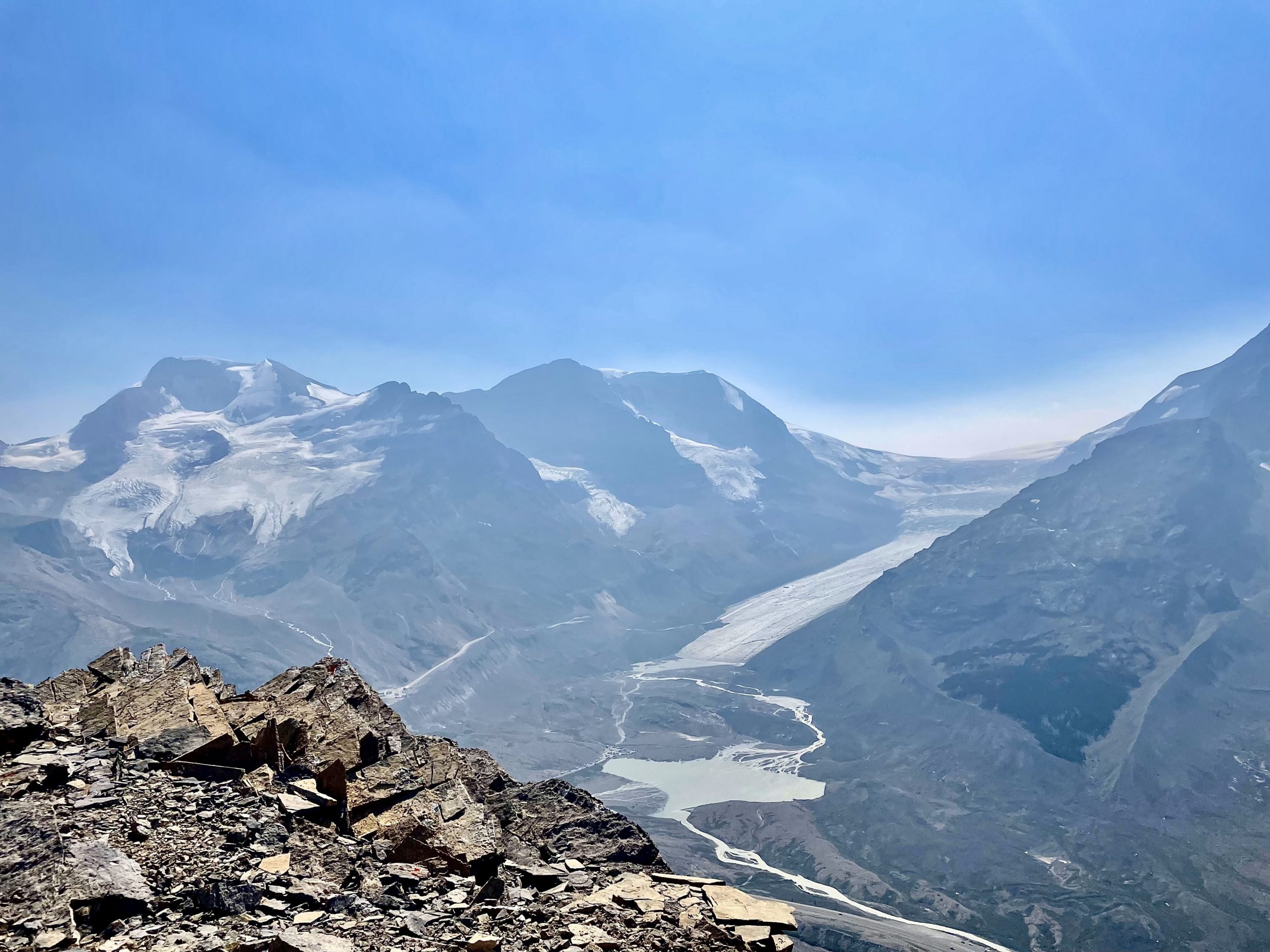
Mt Athabasca (far left) and the Athabasca glacier in Jasper National Park. Image credit: Katherine Hanly
However, climate change jeopardizes the well-being and livelihoods of mountain guides, altering the frequency of objective hazards (e.g., rockfall), shifting the seasonality of the climbing season, and in doing so, undermining the economic foundation of mountain tourism and recreation in the Canadian Rockies. Adaptation strategies are essential for both preserving this iconic landscape and the livelihoods of the dedicated mountain guides who play a central role in showcasing its beauty and challenges.
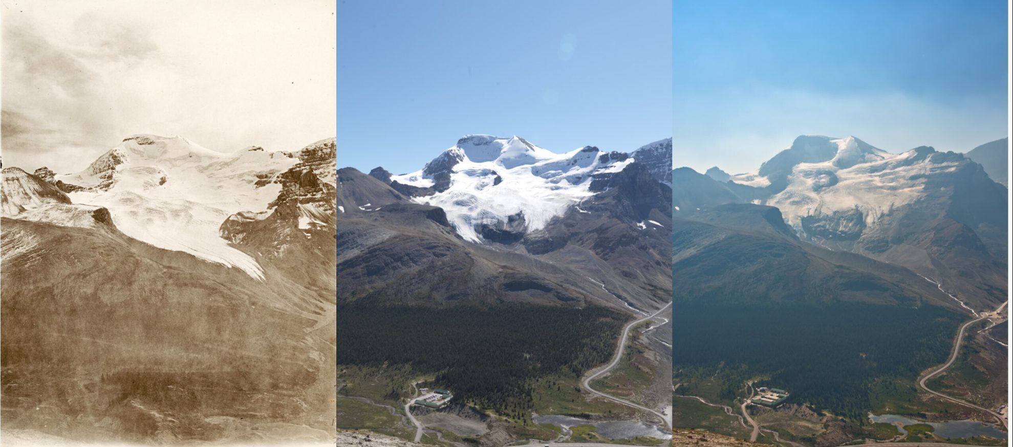
Triptych of historical and repeat images for Mt Athabasca in Jasper National Park. The historical image (left) was captured by A.O. Wheeler as part of the Interprovincial Boundary Survey in 1918. The second image (centre) was captured by MLP researchers in August 2011. The third image (right) was captured by Katherine Hanly and James Tricker in August 2023. Historical im-age courtesy of Library and Archives Canada. Repeat images courtesy of the Mountain Legacy Project, University of Victoria. All images are available at https://explore.mountainlegacy.ca/
Our research aimed to examine both the physical and social effects of climate change on commonly guided mountaineering routes on Mt. Athabasca to better understand the socio-economic conditions that constrain adaptation planning and limit awareness of potential loss and damage in the mountain tourism sector. To do this, we used repeat photography in concert with climatological trend analyses and interviews with mountain guides. Repeat photography served as a powerful visual tool for achieving our research goals because it can capture the transformative impact of climate change on mountainous landscapes as well as the evolution of mountaineering routes and infrastructure woven into this terrain. As such, it allowed us to explore the dynamic relationships between the physical terrain on Mt Athabasca and the social experiences of mountain guides working in this region of the Canadian Rockies (e.g., showcasing alterations in ascent routes because of glacier retreat).
Behind the Lens: Our Journey
In July, we began the process of obtaining, gridding, and printing historical images to assist in identifying station locations during fieldwork. Guided by the expertise of MLP researcher, James Tricker, we estimated station locations in Google Earth by identifying unique foreground features and distinctive terrain characteristics. While hiking up the Wilcox Pass trail, we paused to re-familiarize ourselves with the topography, paying close attention to specific angles and proportions of distinctive features. We also looked for evidence of recent grizzly bear activity, as there had been observations of a sow and two cubs earlier that week!
Thanks to James’ keen eye, we could identify station locations with relative ease and began taking our repeat photographs. Throughout this process we had the pleasure of chatting to numerous individuals with whom we shared the trail, sharing our knowledge of the local area, the work we were doing, and enjoying home-made granola bars courtesy of new friends. Walking home, filled with a sense of achievement and connection to the surveyors who had photographed this landscape before us, we were lucky to observe the grizzlies (from a safe distance) as they frolicked through the hills!

Grizzly momma and cubs heading up to Wilcox Pass. Photo credit: James Tricker
While we had a great field day, embarking on repeat photography during one of Canada’s most severe wildfire seasons presented a significant challenge. Pervasive haze associated with wildfires can impede a photographer’s ability to capture and analyze subtle changes in the landscape, interfering with the accuracy of analysis and complicating field day logistics. However, this challenge also became central to conveying the narrative we discovered in our research.
The smoke in our photographs vividly depicted a dramatic change in Canada’s mountainous landscapes and the cascading effect of this smoke on mountaineering routes. For example, wildfire smoke can darken glacier surfaces reducing albedo and accelerating melt processes, resulting in the loss of snow, ice, and glaciated terrain on mountaineering routes. In the context of escalating climate change, where the frequency and intensity of wildfires are expected to rise, the smoky scenes in our photographs served as a visual testament to the future challenges facing these environments.
Discoveries & Lessons Learned
Despite the challenges we encountered in the field, our investigation revealed that rising temperatures, shifting precipitation patterns, and the retreat of glaciers as well as the loss of semi-permanent snow and ice have had significant effects on mountain guiding and mountaineering activities on Mt. Athabasca. Prominently captured in our repeat image analysis, these environmental shifts have modified climbing conditions on all mountaineering routes on the mountain (delineated by the black lines in the image below). For example, the progressive retreat of the North Glacier (outlined by the red, blue, and yellow lines) has altered the approach to all climbing routes on Mt Athabasca, increasing the distance guides and their client’s must walk to reach the glacier and changed the terrain that they must travel through (i.e., snow and ice to lose scree). The visual depiction of such change provided valuable insight into profound physical transformations unfolding on the mountain.
Subsequent interviews with mountain guides revealed that our observed changes in routes conditions, have also altered the frequency of objective hazards on Mt Athabasca’s mountaineering routes, influencing if and when these routes can be climbed. Guides described that an increasingly early melt of seasonal snow contributes to an extension of the rockfall season, constraining the guiding season to a short window when climbing conditions are preferable. However, despite their exposure to the same physical changes, guides’ experiences of these changes varied according to socio-economic conditions (e.g., financial security, livelihood flexibility). Late-career guides tended to experience loss of guiding opportunity because their comparatively greater financial security reduced the financial pressure they feel to work when conditions are poor. In contrast, early-career guides more frequently felt greater pressure to provide services in more challenging conditions, as they had less financial security. Our findings underscore that for mountain guides, there is no ‘one size fits all’ approach to adaptation and instead, emphasize the pressing need for tailored adaptive strategies that address concerns and priorities within the mountain guide community. For more details, you can read our full article published in Tourism and Hospitality.
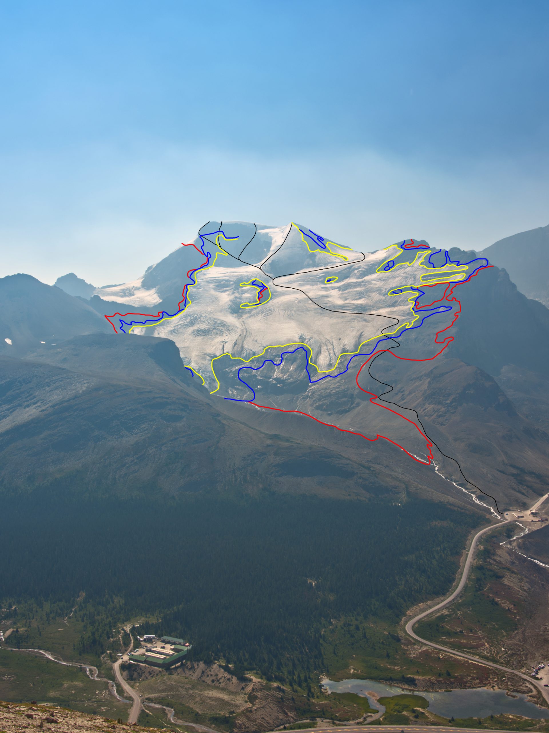
The second repeat of Mt Athabasca captured in August 2023. The red lines indicate the extent of the glacier in 1918, the blue lines are the 2011 extent, and the yellow lines are the 2023 extent. The common climbing routes are delineated in black. Image credit: James Tricker
Conclusions
This study served as a valuable foundation for future research, recognizing that similar underlying issues may be present in mountaineering destinations worldwide. As such, repeat photography and its proven potential to bridge the gap between diverse scientific disciplines and serve as both a tool for local knowledge gathering and a conduit for knowledge dissemination within the wider community, represents an important tool moving forward. Our repeat photograph journey extended beyond the lab into the heart of the Canadian Rockies, encompassing breathtaking landscapes, diverse ecosystems, and the stories of people whose lives are intricately woven into the fabric of these landscapes. The end result was a narrative that documented the progression of mountain landscapes and the evolution of footprints left by generations of mountaineers on iconic routes. Our hope is that this work invites everyone to witness the tangible effects of climate change, fostering awareness, understanding, and a collective commitment to action on climate change.
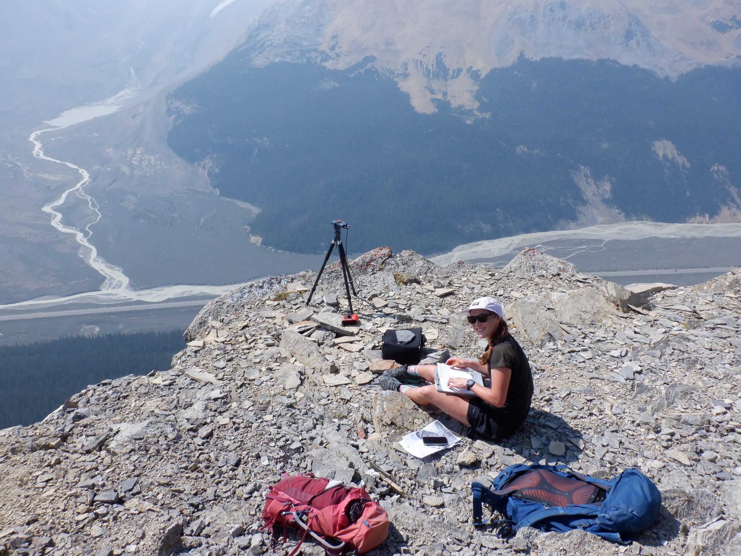
Katherine Hanly recording fieldnotes at Wilcox Ridge #2 camera station. Photo credit: James Tricker
Thank you to those who supported our research endeavors, including the Mountain Legacy Project and the considerable time and resources they donated, Environment and Climate Change Canada for access to climatological data, and the mountain guides of the Bow Valley, who graciously donated their time and shared their expertise.