
By Claire Wright | April 2, 2022
Mountain landscapes are often perceived of as part of the last ‘untouched’ wilderness in the world. In reality, they have long been homelands for Indigenous peoples and are subject to intense and widespread change as a result of human action and the climate crisis. Repeat photography is an effective but underused tool for comparing historical and contemporary conditions in order to understand the transitions taking place in mountain landscapes. The technique consists of replicating certain aspects of a pre-existing photograph, most often the spatial location and view. Repeat photography holds several advantages over other remote sensing methods for monitoring change in the mountains. It allows greater temporal depth compared to satellite and aerial images, with original photographs taken as early as the mid-nineteenth century. The oblique view of the photographs makes them better suited to cataloguing topographically variable and steep terrain. Moreover, the images present landscape change from the human viewpoint and thus lend themselves to visual interpretation, especially for observers who may not be familiar with reading maps and other orthographic products. Repeat photography has a rich history and a promising future for research in mountain landscapes.
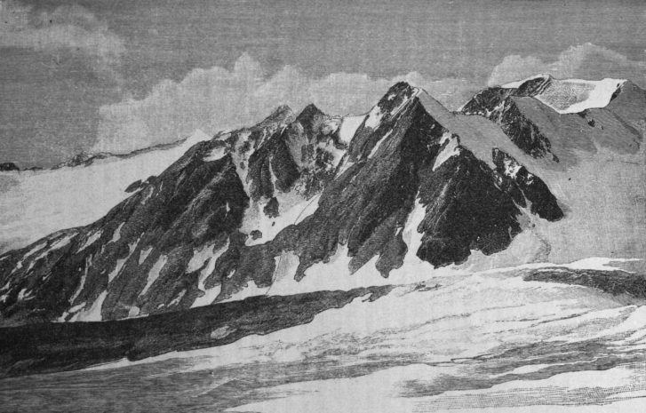
The use of repeat photography to study landscape change has its roots in glaciology and ecology. Sebastian Finsterwalder is often cited as the pioneer of repeat photography in landscape research owing to his use of the technique to examine glacial change in the Alps in 1888. His work was followed by glaciologists in the Sierra Nevada and the Canadian Rockies among others. Repeat photography was also recognized early in ecology as a valuable method for tracking vegetation change in quadrats (typically metre square plots) and over small areas.
“One of the best methods of recording the position of a glacier-front is through photography…“
– Grove Karl Gilbert, 1904
The technique continued to be used in isolated studies, gaining traction in the 1940s, but it was landmark work by Shantz and Turner in the late 1950s that kickstarted the use of repeat photography for documenting large-scale ecological changes through their work in Africa. Shortly thereafter Hastings and Turner published their widely-cited book, The Changing Mile, detailing vegetation change in the Sonoran Desert through 97 paired images. Their research eventually led to the creation of the Desert Laboratory Repeat Photography Collection housing over 35,000 images used in a wide variety of research. Several other large-scale repeat photography projects have emerged including approximately 400 matched photographs collected by Garry Rogers to look at vegetation change in the Great Basin Desert and Mark Klett’s Rephotographic Survey Project consisting of second, and now third, views of late nineteenth century images in the western United States, as well as several smaller efforts across the globe. Klett’s work in particular has had a huge influence on repeat photography, and his books cross the line between documentation and fine art, highlighting the evocativeness of photographs compared to other data sources. From origins in glaciology and ecology, repeat photography has become a widespread, if not widely recognized, tool in the study of landscape change.
As the practice of repeat photography became more common in landscape research, it found a strong foothold in mountain landscapes. In addition to the other advantages of the technique, oblique photographs are often able to provide more comprehensive and detailed views of alpine terrain compared to aerial or satellite images. Early on, Veblen and Lorenz (1991) recognized the value of repeating historical photographs of alpine systems because of the temporal depth provided by the record compared to other lines of evidence. They analyzed 69 photo pairs showing changes in vegetation succession and dynamics in the Colorado Front Range with historical images taken between approximately 1880 and 1915. Meanwhile, Skovlin and Thomas (1995) used repeat photography to study landscape change in the Blue Mountains of northeastern Oregon. In their publication, Interpreting Long-Term Trends in Blue Mountain Ecosystems from Repeat Photography, they note that the images serve as “a visual aid in understanding how ecosystems have changed and are changing.” A few years later, G. E. Gruell demonstrated the practical application of repeat photography through his study of fire-driven ecological change in the forests of the Sierra Nevada.
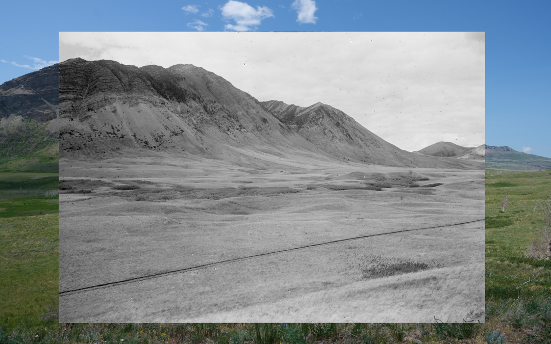
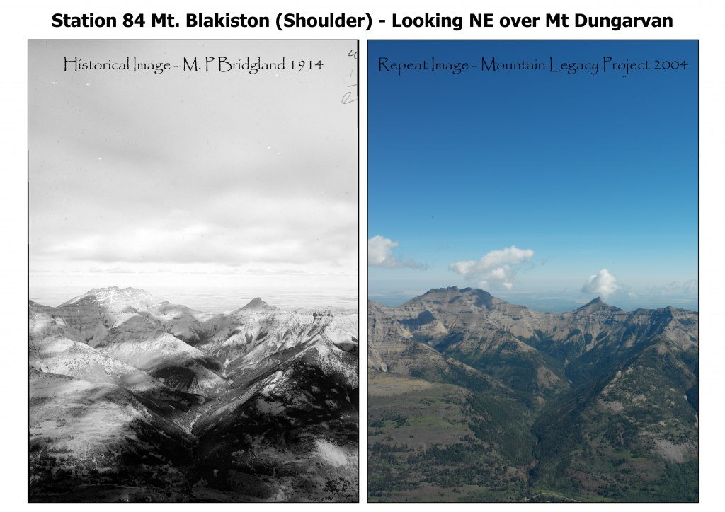
Along with these efforts, one of the largest repeat photography undertakings in the world is the Mountain Legacy Project (MLP). MLP, established as the Bridgland Repeat Photography Project in 1998, accesses a systematic historical collection of over 120,000 high-resolution photographs to study changes in Canada’s mountain landscapes. Close to 10,000 repeat images have been made to date, a majority of them along the front ranges of the Rockies in Alberta. A range of landscape change research has emerged from MLP including studies of large-scale vegetation patterns, alpine treeline shifts, and forest encroachment in grasslands. Researchers working with MLP and other image collections in mountain environments recognize the value of the temporal depth, intuitive presentation, and high spatial resolution provided by repeat photography.
One of the distinctive aspects of repeat photography as a research technique is that much of the power lies in the images themselves rather than any form of data analysis. Paired photographs shown side-by-side serve as visual arguments, conveying the stories behind the times and places depicted, and the changes in between. This form of communication has been recognized since the beginnings of repeat photography when most studies were presented in a narrative form, letting the images take the central focus. For example, The Changing Mile consists of 97 photo pairs with descriptive text accounting for a mere 20% of the book. Despite the lack of data-driven evidence, the book is considered a robust analysis of hypotheses related to landscape change in the Sonoran Desert.
“[The Changing Mile] is much more than a collection of repeat photographs. It is a first-rate compilation of historical evidence bearing on changes in the climate, land use, and vegetation of the Sonoran Desert…”
– Keith White, 1966
Photograph pairs can also be an effective tool for evoking reactions that reveal information about the relationships between people and the objects or events in the images. Originally developed in the field of anthropology, photo-elicitation involves the use of images in an interview to open up dialog between participants and researchers, and to draw out richer information than verbal prompts alone. The technique has been used by MLP researchers to examine conservation and restoration in remote landscapes and to study the experiences of fire lookout observers with wind. Recently, Cassandra Buunk used photo-elicited semi-structured interviews to gain insight into the influence of the devastating 2017 Kenow wildfire in Waterton Lakes National Park, Alberta, on people involved in the management and restoration of the Park’s ecosystems. Previously, another MLP researcher, Trudi Smith, developed an exhibition at the Jasper-Yellowhead Museum and Archives, to connect the public to the Jasper National Park Landscape through repeat photography. As explored by Smith, repeat photography provides a medium for examining both scientific and personal discourses around landscapes. Independent of any form of quantitative analysis, repeat image pairs provide a compelling method for research in mountain landscapes.
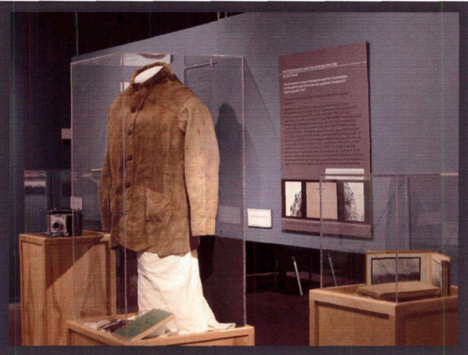
In 2005 Trudi Smith advised on a major 6-month exhibition about the Mountain Legacy Project hosted by the National Library in Ottawa to mark the centennial of the Province of Alberta joining the Canadian confederation.
Repeat photography is a valuable and effective means for understanding change in mountain landscapes. Initially developed as a technique in glaciology and ecology, repeat photography eventually grew in scope to landscape-level research. It has many advantages over other methods for analyzing change in mountain environments including greater temporal depth, increased interpretability, and improved spatial coverage and resolution. Image pairs can be used to investigate scientific hypotheses around mountain landscapes. The images can be equally useful in eliciting information around the relationships between people and the scenes depicted in the images. With all of that said, repeat photography also holds significant potential as a means of conducting quantitative spatial analysis of mountain landscape change at a high spatial resolution and across broad timescales. Part 2 of this series will explore the advances and remaining knowledge gaps in spatial analysis techniques for repeat photography.
References
[1] Wall Reinius, S. (2009). Protected attractions: Tourism and wilderness in the Swedish mountain region [Doctoral dissertation]. Mid Sweden University.
[2] Klett, M. (2011). Repeat photography in landscape research. In E. Margolis & L. Pauwels (Eds.), The SAGE handbook of visual research methods (pp. 114–131). SAGE Publications Ltd.
[3] Kull, C. A. (2005). Historical landscape repeat photography as a tool for land use change research. Norsk Geografisk Tidsskrift, 59(4), 253–268.
[4] Pickard, J. (2002). Assessing vegetation change over a century using repeat photography. Australian Journal of Botany, 50(4), 409–414.
[5] Sanseverino, M. E., Whitney, M. J., & Higgs, E. S. (2016). Exploring landscape change in mountain environments with the Mountain Legacy Online Image Analysis Toolkit. Mountain Research and Development, 36(4), 407–416.
[6] Fortin, J. (2015). Lanscape and biodiversity change in the Willmore Wilderness Park through repeat photography [Master’s thesis]. University of Victoria.
[7] Webb, R. H., Boyer, D. E., & Turner, R. M. (Eds.). (2010). Repeat photography: Methods and applications in the natural sciences. Island Press.
[8] Hattersley-Smith, G. (1978). The symposium on glacier mapping. Canadian Journal of Earth Science, 3(6), 737–741.
[9] Gilbert, G. K. (1904). Variations of Sierra glaciers. Sierra Club Bulletin, 5, 20–25.
[10] Cavell, E. (1983). Legacy in ice: The Vaux family and the Canadian Alps. The Whyte Foundation.
[11] Clements, F. E. (1905). Research methods in ecology. University of Nebraska Publishing Company.
[12] Cooper, W. S. (1924). An apparatus for photographic recording of quadrats. Journal of Ecology, 12(2), 317-321.
[13] Farrow, E. P. (1915). On a photographic method of recording developmental phases of vegetation. Journal of Ecology, 3(2), 121-124.
[14] Griggs, R. F. (1918). Scientific results of the Katmai expeditions of the National Geographic Society: I. the recovery of vegetation at Kodiak. The Ohio Journal of Science, 14(1), 1-57.
[15] Wooton, E. O. (1916). Carrying capacity of grazing ranges in southern Arizona. United States Department of Agriculture Bulletin No. 367.
[16] Rogers, G. F. (1982). Bibliography of repeat photography for evaluating landscape change. University of Utah Press.
[17] Hastings, J. R., & Turner, R. M. (1965). The changing mile: An ecological study of vegetation change with time in the lower mile of an arid and semiarid region. University of Arizona Press.
[18] Klett, M. (2004). Third views, second sights: A rephotographic survey of the American west. Museum of New Mexico Press.
[19] Veblen, T. T., & D. C. Lorenz. (1991). The Colorado front range: A century of ecological change. University of Utah Press.
[20] Skovlin, J. M., & Thomas, J. W. (1995). Interpreting long-term trends in blue mountain ecosystems from repeat photography ( No. 315). USDA, Pacific Northwest Research Station.
[21] Rhemtulla, J. M., Hall, R. J., Higgs, E. S., & Macdonald, S. E. (2002). Eighty years of change: Vegetation in the montane ecoregion of Jasper National Park, Alberta, Canada. Canadian Journal of Forest Research, 32(11), 2010–2021.
[22] Roush, W. M. (2009). A substantial upward shift of the alpine treeline ecotone in the southern Canadian Rocky Mountains [Master’s thesis]. University of Victoria.
[23] Stockdale, C. A., Macdonald, S. E., & Higgs, E. S. (2019). Forest closure and encroachment at the grassland interface: A century-scale analysis using oblique repeat photography. Ecosphere, 10(1).
[24] Parker, K. W., & Martin, S. C. (1952). The mesquite problem on Southem Arizona ranges. USDA Forest Services, Circular 908.
[25] Shantz, H. L., & B. L. Turner. (1958). Photographic documentation of vegetational changes in Africa over a third of a century. College of Agriculture, University of Arizona, Report 169.
[26] White, K. L. (1966). [Review of The changing mile: An ecological study of vegetation change with time in the lower mile of an arid and semiarid region by J. R. Hastings & R. M. Turner]. The Quarterly Review of Biology, 41(3), 318-319.
[27] Harper, D. (2002). Talking about pictures: A case for photo-elicitation. Visual Studies, 17(1), 13–26.
[28] Lapenta, F. (2011). Some theoretical and methodological views on photo-elicitation. In E. Margolis & L. Pauwels (Eds.), The SAGE handbook of visual research methods (pp. 201– 213). SAGE Publications Ltd.
[29] Falk, J. (2014). Historical landscape change in remote mountainous parks: Management challenges observed through a repeat photographic lens [Master’s thesis]. University of Victoria.
[30] Walsh, K. A. (2016). Blowin’ in the wind: Encountering wind at fire lookouts in the Canadian Rocky Mountains [Master’s thesis]. University of Victoria.
[31] Buunk, C. (2018). Mountains on fire: Making sense of change in Waterton Lakes National Park [Master’s thesis]. University of Victoria.
[32] Smith, T. L. (2004). Vantage points: Scientific photography in Jasper National Park [Master’s thesis]. University of Victoria.
[33] Finsterivalder, S. (1889). Aus den Tagebüchern eines Gletscher-vermessers.