With the arrival of the first COVID-19 cases in Canada in late January, and ensuing months of self-isolation and restrictions, a dark cloud of uncertainty reigned over the MLP’s summer fieldwork plans. Our expectations quickly shifted from the typical 6-week field season roving around the Rockies to the prospect of no season at all. However, as the surreal spring months wore on, glimmers of hope for a shorter field season emerged. With revised plans in place allowing for three weeks of UVic-approved COVID-safe research, we completed our final preparations and departed mid-August for the mountains.
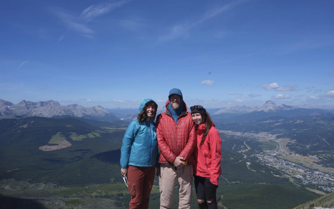
We began our fieldwork in southern Alberta. Our small crew of three University of Victoria students, James Tricker, Kristyn Lang, and myself, settled into the town of Hillcrest, one of five small communities that are part of the Municipality of Crowsnest Pass. The area is known for its history of coal mining activity, with many underground mines operating during the first few decades of the 20th century.


Left: a hefty piece of coal from the historical Coal Creek mining community. Image: S.Voicescu, 2020. Right: The International Coal and Coke mining company in Coleman, 1938. Image by T. Gushul, courtesy of the Crowsnest Museum.
Crowsnest Pass is also surrounded by spectacular mountain scenery. Equipped with our well-worn hiking boots and faithful Fuji GFX 50s camera, we set off for the hills and peaks to repeat historical photographs of these unique landscapes.

Our photographic goals for the first part of our field season primarily focused on supporting my PhD research, which aims to determine ecological and cultural drivers of change in the mined landscapes of the Crowsnest Pass. In collaboration with the Crowsnest Museum, we engaged in an exciting opportunity to repeat historical images from the Museum’s collection. These images offer a distinctive perspective on local communities and their surrounding landscapes, and how they evolved and changed before and after the development and decline of the mining industry. Instead of climbing the usual high peaks, the first week of fieldwork was spent navigating spiralling streets, historical sites, and a few abandoned coal spoils; a different, but nonetheless fascinating experience!
We began our field season at the Leitch Collieries Provincial Historical Site and nearby West Canadian Collieries mine in Bellevue. Although the mine entrance was easy to locate as it serves as the entry point for underground tours, the surrounding rock walls and hills have changed significantly over the past 100 years from mining activity and the construction of the Crowsnest Hwy adjacent to the site. Aligning modern views with historical features that simply no longer exist was very tricky, and a challenge we had to overcome for several images we repeated in the region.
-
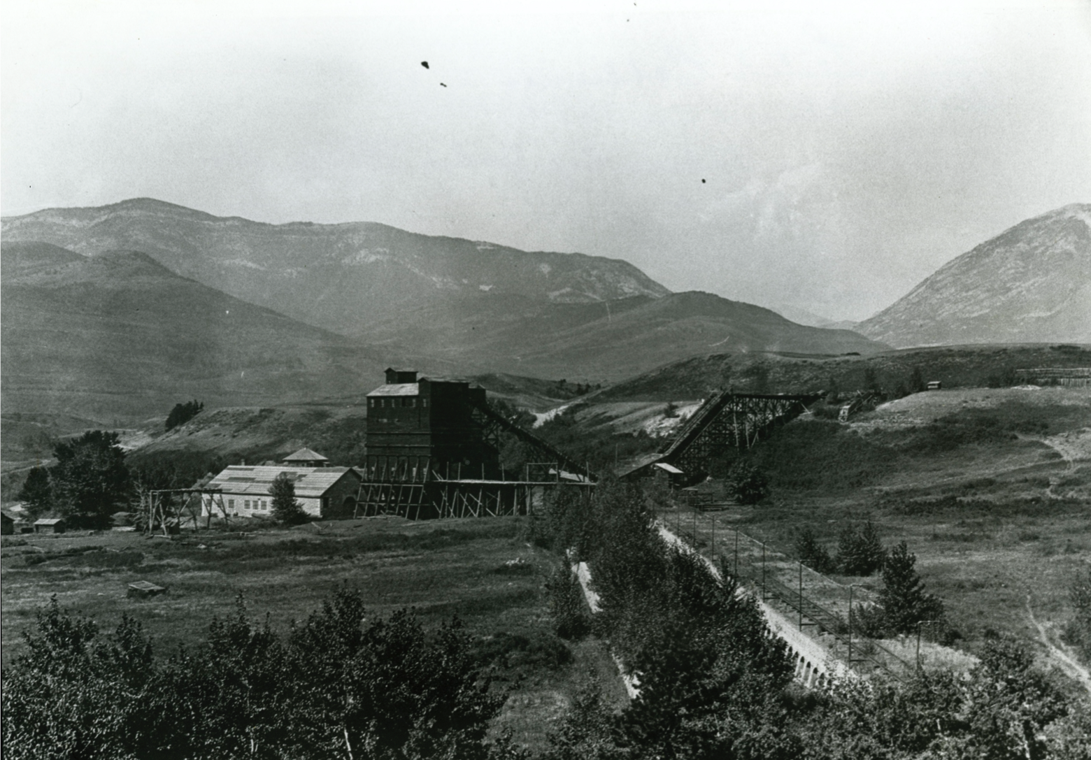
Leitch Collieries, 1920. Image courtesy of the Crowsnest Museum. -

Leitch Collieries Provincial Historical Site, MLP repeat, August 2020.
By mid-week, we ventured back across the B.C. border to repeat photographs in nearby Fernie and Coal Creek. These repeats were also challenging due to new infrastructure and vegetation blocking our views. We were fortunate to have longtime MLP collaborator and Research Associate Rob Watt join us in Fernie. Rob shared invaluable historical knowledge of the area and location finding techniques. He continued to accompany us for a few more days in the Crowsnest Pass, including on an adventure partway up Turtle Mountain to repeat an early 20th century view of Blairmore.


Left: Rob Watt and Kristyn Lang carrying equipment on Turtle Mountain. Image: S.Voicescu, 2020. Right: Mountain view of Blairmore. Image from the James Gatto-Bernie Jenkins Collection, courtesy of the Crowsnest Museum.
We eventually made it to the top of Turtle Mountain, thanks to helicopter support from the Alberta Agriculture and Forestry (AAF) office in Blairmore. This allowed us to perform hover shots of a few historical aerial images, before we were dropped off on the North summit of Turtle Mountain.
Turtle Mountain is notorious in the region for the Frank Slide, triggered from its eastern face. Early in the morning on April 29th 1903, 110 million tonnes of limestone came tumbling down the mountain onto a portion of the town of Frank below, forever changing the landscape in the area. While the scale of the slide is already impressive from ground level, hiking amongst the cracks, faults, and buzzing geological instruments atop Turtle Mountain is an altogether surreal experience. On August 14th we hiked from the North to the South summit and back, repeating historical images from the 1914 A.C. Sheppard survey.


Left: The Frank Slide from the top of Turtle Mountain. Right: Kristyn Lang and James Tricker navigating through some impressive terrain on Turtle Mountain. Images: S.Voicescu, 2020.
Our final days in the region were spent in quite a different environment. Along with Rob Watt, we visited Tent Mountain, which lies on the border between Alberta and B.C., approximately 16 kilometers southwest of the Crowsnest Pass. Tent Mountain was the site of the last operating coal mine on the Alberta side of the Crowsnest Pass. It closed in 1983 without being reclaimed. There is a proposal in place to re-mine the area, with mining operations expected to start in 2021. Thanks to collaboration with community liaison officers from Montem Resources, the MLP team was able to access the site and repeat some long-outstanding images from the A.O. Wheeler 1914 Interprovincial Boundary survey. Here, we found locations where historical images were taken thanks to original boundary markers and mossy survey sticks.

Overall, we managed to repeat 71 historical images from 19 different locations in this area, which exceeded our expectations in such a turbulent year! After eight days spent in the Crowsnest Pass, we packed our gear and headed North to Kananaskis Country, where more mountain landscapes awaited us.
To learn about the rest of our research this summer, stay tuned for Part 2 of our Fieldwork series, which will be published in early 2021.
Acknowledgments
I would like to personally thank the following people and organizations, whose support and collaboration were essential to the success of our work in the Crowsnest Pass: Rick Arthur, Alberta Agriculture and Forestry (Blairmore office), Rob Watt, Heather Davies from Uplift Adventures, as well as Chris Matthews and Michelle Cavanagh from the Crowsnest Museum, who provided tremendous outdoor and indoor support during our time in the Crowsnest Pass, and community liaison officers from Montem Resources, who facilitated our visit to Tent Mountain.
More information
Mining, Memories, and Mountains
A blog post I wrote this past summer reflecting on cultural and ecological changes in mining communities, which is the focus of my PhD research.
Great website on the history of the region and its different communities. Also a great source of information for popular heritage hiking trails.
For more information on the history and significant events that occurred in the Crowsnest Pass, I also recommend the following readings:
Langford, T., & Norton, W. R. (2002). A World Apart: The Crowsnest Communities of Alberta and British Columbia. Plateau Press, Kamloops, British Columbia, Canada.
Norton, W., & Miller, N. (1998). The Forgotten Side of the Border: British Columbia’s Elk Valley and Crowsnest Pass. Plateau Press, Kamloops, British Columbia, Canada.
Wilson, D. (2005). Triumph and tragedy in the Crowsnest Pass. Heritage House Publishing Co. Ltd., Victoria, British Columbia, Canada.