Have you ever come across towns whose very presence on the landscape hint at multiple stories and complex histories? Perhaps it’s the façade of a particular building that doesn’t quite fit with the more modern design of its neighbours. Or maybe it’s the sinuous way the main street spirals towards a particular landmark, guiding the development of businesses and residences in its wake. Sometimes it’s the entire surrounding landscape, an intricate product of cultural and natural forces, that offers clues into what might have happened on the land, and of what is yet to come. All landscapes have stories to tell, but unravelling the threads that link these stories together can be a complicated process.
I first encountered examples of such complex landscapes last summer, while doing fieldwork for the Mountain Legacy Project (MLP). This project, with its collection of over 120,000 historical and 9,000 repeat images of Canadian mountain regions, can provide different perspectives of land use change, and guide us in revealing these landscape stories.
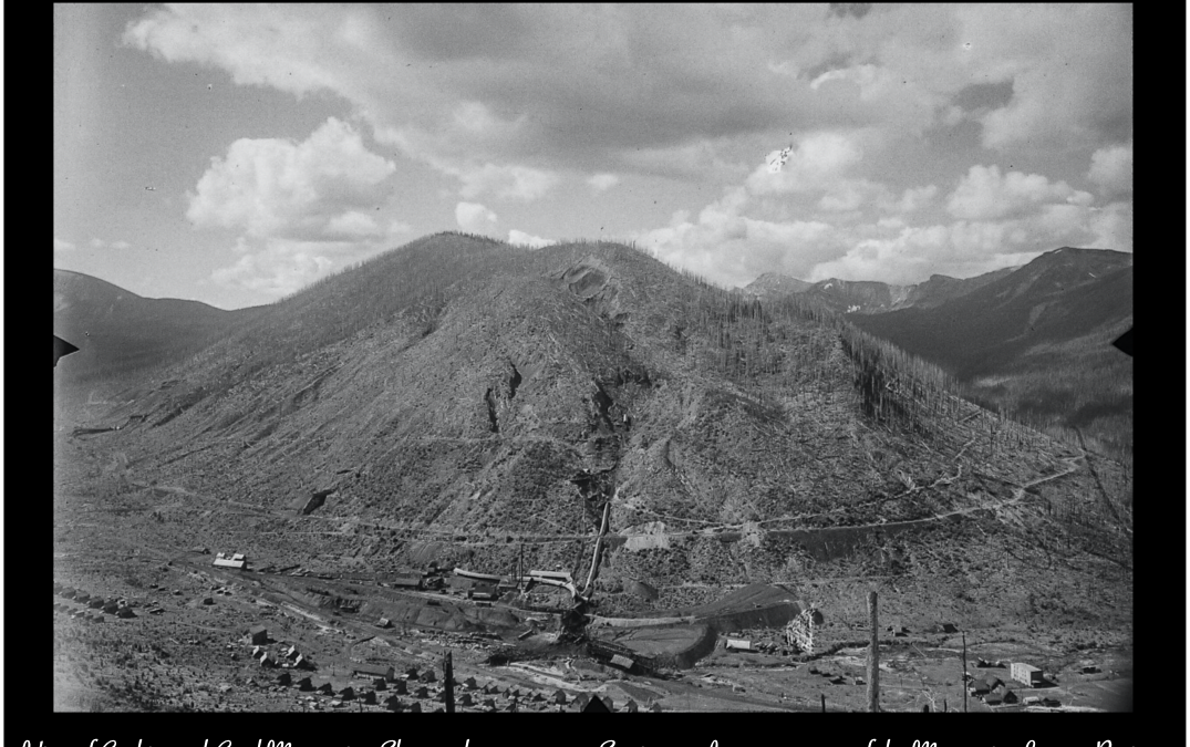
What began as a pretty typical day for the MLP field crew soon turned out to be more complicated than expected! On a sunny July day, we were tasked with the repeat of a set of images from 1930 that overlooked the town of Hillcrest in the Crowsnest Pass. One original image showed two large homestead properties in the foreground, along with mining infrastructure in the background. Surely such prominent features would be easy to locate, and we would be done in no time!
-
View of Hillcrest community and Hillcrest Mohawk Mine; Crowsnest Pass, Alberta. Image taken from Bellevue, MacDonald 1930 Station 7 survey. -

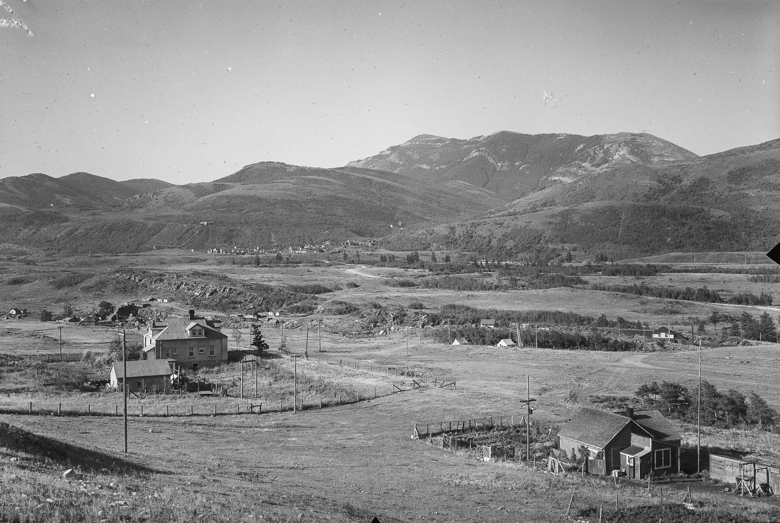
Mountain Legacy Project repeat, July 19 2019.
We began by aligning the mountain views in the background. Hillcrest Mountain stood tall and proud, and to the West, we could see the rise of Turtle Mountain, the “Mountain that Moves” from which the Frank Slide was triggered one fateful morning in late April 1903 [1]. The team was happy with that alignment, but we couldn’t quite figure out what had happened to the properties in the historical image. We looked everywhere for them, but they were nowhere in sight, along with the remains of the mining operation. After attempting multiple panoramas from other nearby locations, we decided to venture into a grassy spot in front of us, to see if perhaps we could get a different view on these missing buildings.
Suddenly, we stumbled on the remains of a vehicle, and further down we spotted some rusty fence posts and the overgrown rubble of a house foundation. After threading through the tall grass a while longer, we discovered more vestiges of what clearly used to be a large property. We had finally found our missing houses, just not exactly in the condition we expected them to be in.


Left: Remains of old fence and fence posts. Right: Front axle from historical vehicle. Images taken onsite by the author, at MacDonald 1930 survey, Station 7, July 19 2019.
Images like the one we repeated, which display a different story than the one we were currently experiencing, are abundant in landscapes which have been modified by human activity. Looking at the remains of those properties made me reflect on what it means to have visual legacies of a common historical past. If artifacts, landmarks, or even entire landscapes are erased, can people still experience them? How would they value what is gone compared to what is present or what might be, in a landscape that is undergoing high levels of change?
Mining landscapes are perfect examples where one can explore such questions. Through their remodeling of landforms and topography, mining and reclamation can create entirely new features on the landscape. Sometimes this has positive consequences for local communities, by promoting new business and recreation opportunities. The Bonne Terre lead mine in Missouri, for example, was flooded after operations were terminated in 1962. Two decades later, local entrepreneurs and diving enthusiasts turned the site into the largest freshwater scuba diving venue in the world, boasting over 17 miles of navigable tunnels that allow visitors to be literally immersed in mining history [2]. In Scotland, waste piles from 19th century shale oil extraction became hosts to unique assemblages of flora and fauna, as well as promoting a network of trails that allows local communities to explore their industrial past [3].


Left: Diving at Bonne Terre historical mine, Missouri, USA. Source: Bonne Terre Mine Boat and Walk Tours, 2020. Right: Shale bing, West Lothian, Scotland. Source: J. Delaney, 2019.
Other times, the development of new landforms resulting from mining activity can not only modify ecological relationships within a landscape, but it can also erase cultural and historical ones. In certain communities, mining has become a part of a common identity and sense of place. The mining landscape can define what people call home, and allow memories and stories to be reproduced and shared between generations [4].
Inherently, by moving communities and stripping down landscapes for access to their mineral depths, mining can reshape and remove visual legacies that are part of a common heritage. Even after mining activity has ceased, practices designed to recover lost features and functions can nonetheless replace elements of the mining landscape with others that do not have the same cultural significance.
Reclamation (the practice of converting disturbed land to its former or other productive uses [5]) and restoration (the process of assisting the recovery of an ecosystem that has been damaged, degraded or destroyed [6]) are both examples of such practices. These approaches to landscape recovery will often involve disposing of the remains from the activity that caused the land degradation in the first place. For mining landscapes, this could mean removing spoil piles and infrastructure, and reseeding the area with fast-growing vegetation.
While there are evident ecological benefits to these activities, for mining communities that have evolved alongside industrial activity for many decades this might mean the removal of familiar landforms and landmarks that serve to perpetuate cultural identities. How does one decide then what to prioritize between environmental attributes and cultural ones, when both serve essential functions on these landscapes?
This question highlights that mining landscapes are complex, and often project different narratives. For the people and ecosystems that experience them, they can result in either prosperity or decline, hope or desolation, life or death [7]. And to truly understand them, one must look at how both ecological and cultural narratives have interacted and continue to interact on these landscapes.
As the mining industry continues to be an important sector in the Canadian economy, and technological developments are allowing for previously inaccessible areas to be mined, we must ask ourselves what represents a meaningful recovery of these landscapes. The ways in which we intervene must be able to preserve both ecological and cultural memories of a place, so that future mining landscapes are able to retain the layers that makes them so unique in the first place.
More information
CBC article by Robson Fletcher, Drew Anderson and Jordan Omstead that explores conflicting perspectives of coal development in Alberta, particularly with regards to the effects of the 1976 Coal Development Policy and its recent rescinding by the UCP government.
This work by photographer Peter Goin and historian Elizabeth Raymond examines the visual and cultural legacy of mining landscapes in the United States, and presents different mine sites as evolving cultural artifacts within the American landscape.
Hourdequin, M. and Havlick, D.G., Restoring Layered Landscapes: History, Ecology and Culture. Oxford, UK: Oxford University Press, 2016.
This book focuses on ecological restoration in “multi-layered” landscapes with complex histories. The authors give examples of landscapes that have been shaped by interactions between humans and nature, which challenges the identification of reference conditions and raises questions about the role of ecology and history in restoration.
References
[1] Frank Slide Interpretive Centre, “ Learn about the Frank Slide”, June 2020. Available: https://frankslide.ca/learn. [Accessed July 3, 2020]
[2] Atlas Obscura, “ Bonne Terre Mines”, 2020. Available: https://www.atlasobscura.com/places/bonne-terre-mines. [Accessed June 17, 2020]
[3] J. Delaney, “ Heritage trail to explore history of West Lothian oil boom”, Edinburgh Evening News, June 11, 2019. [Online]. Available: https://www.edinburghnews.scotsman.com/news/people/heritage-trail-explore-history-west-lothian-oil-boom-545627. [Accessed June 17, 2020]
[4] R. Wheeler, “ Mining memories in a rural community: Landscape, temporality and place identity”, Journal of Rural Studies, vol. 36, pp. 22-32, October 2014.
[5] M.A. Naeth “ Land Reclamation”, Canadian Journal of Soil Science, vol. 92, no. 1, pp. 1-5, January 2012.
[6] G.D. Gann et al., “ International Principles and Standards for the Practice of Ecological Restoration, Second Edition”, Society for Ecological Restoration, November 2019.
[7] R.V. Francaviglia, Hard Places, Reading the Landscape of America’s Historic Mining Districts. Iowa City, IA: University of Iowa Press, 1991.