Since our last post, we’ve had the full spectrum of Willmore weather: thunder, lightening, rain and blinding sunshine, with rainbows in between:
Thunder and lightening almost every evening for three days. We heard the weather warning on our radio the day before the weather moved in, with 70-100 mLs of rain in the forecast!! Well, we certainly heard and saw it coming down in buckets.
We took advantage of the rainy days to get a lot of organizing and office work done. Thursday afternoon we headed in to town to do a presentation for the Grande Cache Aboriginal Junior Forestry Rangers program participants, which was great!
We also headed down to Edson for a delightful chat with the Edson Fire Center crew. At the tail end of the meeting, Jenna had remembered to ask about historical photos taken from some of the fire lookout stations that someone had mentioned to us briefly before. And with the largest ounce of luck, Kevin Freehill had saved several photo books that contained images from 1966 for several of the towers around Grande Cache! He said he found them before they were thrown out, because of a clean-up effort. We hurried downstairs to scan and copy the books of 10 or 11 images for the Adam’s Creek, Huckleberry, Simonette, and Grave Flats lookout towers, and made it a goal to add them to our workload while here. As they are fire lookout centers, they were brilliantly placed for excellent views of the landscapes around them.
When the sun came out the morning of the fourth day, Friday, it looked like this from my bedroom window:
Friday started somewhat sunny in the morning, but the skies quickly became cloud-filled and thunderstorm-y by mid-afternoon.
At Station 21, we had a bit of time to spare, while waiting to be picked up by Alison, so these two events took place:
In the image above, you can also see Jenna’s dream come true! Earlier that morning, while we waited to load the helicopter, she got into conversation with Matt, the crew leader of the fire fighters here. Turns out he had an old NOMEX suit – the flame-resistant suits the firefighters we’ve seen wear for their work – and she jumped into it faster than your can say, “Banana suit”. The suits were designed for firefighters and race car drivers both, after the fiery deaths of three racers in 1964. She spent the day warm in her bright yellow one-piece, while I put on toque, gloves, and extra layers to avoid the chills.
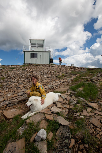
Then we headed for our first of the newly founds: the Adam’s Creek Lookout Tower, where our pilot, Alison, was to pick up carpenter, Paul Shannon, that had been helping the Lookout Tower Observer.
We landed to this:
And this:

Jenna, Chopper (the gorgeous white dog who belonged to the Adam Creek Lookout Tower’s Observer, Brian), and Heike walking down from the tower. (Photo credit: Mary Sanseverino)
Paul seemed very interested in the work we were doing, and was up on the outside of the lookout tower, peering over shoulders and asking questions, and pointing out landscape changes from the original photos. Jenna let him look through the camera, but he didn’t end up pressing click!
Afterwards, we got rained out of Station 17, so we called it a day because of the dark thunderstorms that were booming, and the giant rain cells that were coming in.
Saturday followed the same weather patterns as Friday. We managed to get three stations completed before we were rained out of the fourth.
Station 16 was a beautiful, lower elevation, slightly sloped ridge-top. Gorgeous views to the river bottoms and valleys immediately around us, and then the mountains climbing certainly to the South and West of us, and a few more before the foothills began on the East. This station also had one of the biggest cairns we’ve had yet!

Mary and Jenna, Station 16, with the enormous cairn. Visible behind them, is the weather, building. (Photo credit: Heike Lettrari)
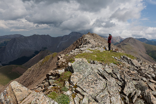
For Station 18 we had a nice hike along this rocky ridge top:
And also had this delightful treat:

Slightly over-exposed female bighorn sheep (the zoom on my camera isn’t that good)! We counted 7 from the helicopter. Five show themselves here. (Photo credit: Heike Lettrari)
What a gorgeous day. However, the good weather didn’t last long. On our walk up to the fourth station, we had to turn back a short distance from the rocky peak, because this was coming our way:
I had foolishly thought we’d walked our way to the edge of it, as we only had a light splattering of rain after our walk down started, but moments before we reached the helicopter, it started to pour. Our pilot, Alison, had battened down the hatches (the helicopter blades), and covered the few critical mechanical components that needed to remain out of the reach of the weather, and then we clustered into the helicopter:
We made the best of the situation – our cozy half hour of fogging up the windows – and shared carrot sticks and cookies:

Fuelling up. Mary offering Alison, our lovely pilot, a few choice carrots. (Photo credit: Heike Lettrari)
The temperature dropped to 2 degrees Celsius, which has us closing the windows and being grateful for the layers we’d packed. When the rain let up, and we took off, navigating the weather cells like a soccer player does opponents and goal posts.
This was also the day that we got to see Mt. Robson off in the distance! Alison was the only one to snap a photo with her iPhone, as ours were stashed in the back, so we’ll post that as soon as Alison forwards it. What a great sight and motivation for the next stage of our journey.
SUNDAY: for some, a day of rest; for others, the day that starts a new week; and for others still, just another day on the weekend. For us, Sunday was our biggest day in the Willmore. We completed EIGHT stations. That is a record day. We started just after 8 in the morning, and had completed five stations by noon. We completed one more ground station after that, and finished up with two hovers, as the weather was picking up. Alison did a great job at our Station 3, hovering at about 8000 ft, in an updraft the crept over the top edge of our ridge:

Jenna with the camera, having finished a hover shot. I held the photos, Mary wrote the field notes, and Alison controlled the helicopter! Great teamwork! (Photo credit: Mary Sanseverino)
Here are a few shots of the highlights:

Station 19: rained us out Saturday, but we got it, first thing, Sunday morning. Jenna and Mary lining up the photo. (Photo credit: Heike Lettrari)

Mary, packed up and ready to head down to our pick-up spot for the helicopter, Station 15. (Photo credit: Jenna Falk)

Getting intense (and we’re not even camping). Mary holding the image, Jenna shooting. Station 12. (Photo credit: Heike Lettrari)

Jenna lunching on squished kiwi and plum; Heike finishing fieldnotes. Station 12. (Photo credit: Mary Sanseverino)

Stegosaurus spine! The cairn on Zebra Mountain, Station 3. Reminiscent of tens of millions of years ago. (Photo credit: Heike Lettrari)
MONDAY. Yesterday.
We decided to try to complete one of the three lookout towers for this area. We packed up the truck, and headed for the Huckleberry Tower. The drive was great. Short jump on the highway, and a skip along gravel roads: Goodwin, to Smokey Main, to the Huckleberry Connector. All went well, until a ways up the Huckleberry Connector, when we encountered a white pick-up truck parked on the road. No room to get around. We parked behind it, not quite seeing a spot to turn around, and headed up by foot. I took the photo below, smiling, thinking this was one of the muddiest stretches we walked through, though later that afternoon we would curse the rain that turned the road to muck worse than this:
The road walk took us along a few beautiful spots, and I was able to capture these two images from a pond we passed. In some ways, the slower pace of a walk affords enjoyment of the scenery in a way much different than travel by a vehicle.
We made it to the Huckleberry Tower after a short lift from the observer, Karen, who proved to be a very generous host. She plied us with tea, and freshly-picked huckleberries (how fitting!), and showed us how to climb up her 120 ft tower safely. On came the fall-arrest harness, and up went Jenna, first:
Mary and I waited below near the pulley system, which we would use to hoist up the camera, tripod, and goodie bag filled with the tools we use to record the environmental conditions at the time of the repeat photos (a Kestrel 3500, a compass, and GPS):

Mary standing beside Karen (whose shadow you can see!), standing beside the phenomenal pulley system.
While it’s sunny in the photos, it didn’t take long for the bad weather to pull in. Mary and Jenna ended up waiting out a bit of rain, before lowering the camera, and then making their own descents, and after the short and noticeably muddier drive back down to where Karen originally picked us up (saving us about 4 kilometres of further walking), we had what seemed a much shorter walk back to the truck.
We managed to turn the truck around no problem, but then…
WARNING: DO NOT ATTEMPT AT HOME. PROFESSIONALS WERE USED TO COMPLETE THE FOLLOWING MANEUVER AND BACKWOODS EXIT.
We started to drive back down our road, but minutes later were startled to find the back end of the truck almost 45 degrees to the road, and slipping more! After Mary’s excellent counter-steering, we hopped out to find an inch of mud on the tires, which left us practically no traction. We picked up rocks, and scraped off the tires. We grabbed water bottles and poured water across the tires. We dug our nails into the grooves of the tires, trying to shake off the mud. That worked.
For about 200 meters.
We climbed out and repeated the same thing. I’m not actually sure how many times we stopped to do that, but let’s just say Jenna’s arm’s sore today, and the inside of the truck will need some special attention to get all the mud out, and those five kilometres or whatever the distance was, back to Smokey Main (a much better, gravel road), seemed a long, long, long way off (too far!!).
Near the end we found ourselves facing a particularly tricky downhill slope that made even Mary nervous. And, we had a giant logging truck coming up behind us. We’d just passed an active cut block, and I’d seen the men packing up to head home for the day. After a bit of help and a few tips, we made it safely back to the better dirt road, which led to the highway, which led to our fire base, and us returning in time for dinner. Phew. What a day.
THE GOOD NEWS: we didn’t make (what we consider to be our Albertan theme song) Corb Lund’s truck song come true, as the truck DID NOT get stuck:
[youtube https://www.youtube.com/watch?v=pDY6bWT5oTM]
Thankfully, we can still play that while we drive.
While we briefly considered it, we didn’t take any photos from our mudfest adventure, simply because our hands were as muddy as the tires, basically until we made it to the better dirt road. No one wanted to muck up a camera for one photo.
The next few days sees us cleaning the truck, packing up, returning the borrowed gear from the Edson Fire Center, and heading to Mt. Robson’s provincial park. Until the next post,
MLP out!


Great photo’s and stories! Thanks for letting the rest of us live vicariously. Well played Jenna, getting your hands on some nomex!
Thanks Stuart!
Jenna is most pleased with the nomex, though living out the suit quietly for now. 🙂 We’re back at the Shunda Fire Base now, wrapping up some of George Malloch’s 1908 coal survey stations, with one more left around Mt. Robson. We cross our fingers for good weather!
Oh man I just found this – thanks indeed for the vicarious MLP experience! You guys are going to all the good spots! K-country, Clearwater, WILLMORE!! (and hiking it!) All the best for Mt. Robson, can’t wait to see the next post. What sites are you doing? Jenna I’m jealous of the banana suit.
All best to you guys from the Himalayas…
ellie
Ellie!
We all send our best wishes for you, and are still in awe that you’re in the HIMALAYAS! Any chance of connecting to Oliver Wheeler’s historical photos from there? 🙂
In Mt. Robson we’ve done Wheeler’s Yellowhead Pass Station (discussed in the most recent post), and we’re going back to do the Moose Lake station, after we wrap up our time here in the Clearwater. We also spent the better part of a day locating historical cultural photos, each of which have stories of their own! I don’t know if we’ll get the chance to repeat any of those anymore, but we’ll see what time can permit in the coming days.
Wishing you well!
Heike