On October 5th, 2018, Spark, CBC Radio’s weekly program exploring technology, innovation and design, went out with the Mountain Legacy Project to do some repeat photography. Full disclosure – the repeat photography session actually happened in August this past summer. Meg Wilcox, a Spark contributor and journalist with deep roots in the mountains of western Canada joined the MLP crew for an “in the field” interview. Meg met up with Karson Sudlow, Sonia Voicescu, and Rick Arthur at Elbow Falls Provincial Recreation Area out along the eastern slopes of Alberta’s Rocky Mountains. In classic MLP fashion not only did the crew demonstrate the field processes and talk about landscape change, but they put Meg to work helping to locate the spot the historic images were taken from. Read the introduction and listen to the interview online at CBC Spark.
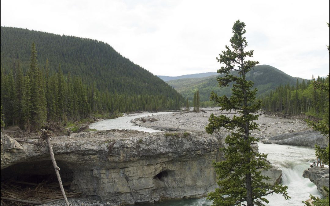
The group was on the hunt for a photo taken in1897 by Arthur Wheeler. The day was a bit smokey, but they successfully found the vantage point (aka “station”) where Wheeler stood when he captured Elbow Falls on glass plate. Wheeler’s image included the falls itself, a cliff face just east of the cascade, and the careful placement of two survey crew members on a rocky outcrop overlooking the river. The 2018 MLP team occupied the same station as Wheeler and repeated the photograph, complete with sending two people out on the rocky outcrop to stand in for the 1897 crew.
Click the side-arrows on the image below to fade between the modern and historic images — remember to look at the lower right to see the crew!


This historic image was one of over 400 produced by Arthur Wheeler and his team from the years 1896 – 1899. They were surveying and doing photo-topographical mapping in the front ranges and eastern foothills of the Rocky Mountains in southern Alberta. The surveys went from Jumping Pound, just south of today’s Highway 1 and west of Highway 22, south through Sheep River Provincial Park. The most southerly photo station sits some 50 km south of Sheep River on top of Mt. Speke, just outside of the Bob Creek Wildland.
The federal government of the day, along with a number of private organizations like the Canadian Pacific Railroad, were interested in large-scale irrigation projects. Hence Wheeler’s remit to undertake mapping surveys in order to determine the water supply in various watersheds. The maps would also prove useful in helping to explore the feasibility of building irrigation canal systems.
As always, MLP teams seek to stand where the historic surveyors stood and repeat their photographs as accurately as possible – we are usually within a metre. But, sometimes the land where the surveyors stood has been sufficiently altered such that MLP researchers can’t get right to the exact spot. That’s what occurred here at Elbow Falls – the park has built up a series of ramps, walls, and viewing platforms and Wheeler’s station was right under one of the walkways. The crew had to take an “alternate” shot. Still very good, but, unless they pulled out a jackhammer and put a hole in the concrete, probably off by one or two metres.

Sonia and Karson lining up Wheeler’s 1897 shot of Elbow Falls. Photo by Meg Wilcox
There’s lots of change to see in the photographs – notice how the trees have filled in much of the hillsides in the modern image. Also, notice how much wider and rocky the river’s course appears in the modern shot — this is a direct result of the 2013 floods that inundated SW Alberta in June of that year. It is also interesting to note how similar the geology seems – the cave and cliff face seem very much the same, even though more than a century separates the images.
More resources
To examine the images in more detail click on the Explore Mountain Legacy website.
Explore CBC Spark for more stories on innovation and technology.
Visit Meg Wilcox’s new media débrouillarde website (you’ll be glad you did!!).