Because we’ve covered so much ground in the past 3 weeks, we figured an update in a ‘feature-in-three-parts’ would be appropriate, until we’re caught up, and can do more thorough, and current posts! So, here’s the start to catch-up!
PREAMBLE:
We hit the road from Victoria early in the morning on July 1st. After about a 12 hr drive, we pulled in at the Lettrari family residence, where we stayed the night, in Kaslo, BC. Our route: Victoria, Vancouver, Hope, Princeton, on the picturesque Crowsnest Highway (Hwy 3) to Osoyoos, on to Castlegar, Nelson, and Kaslo. The next day, up early again, we drove to Revelstoke for phenomenal tea and lunch with Mary’s sister, Janice, then on through the beautiful Glacier, Yoho, and Banff National Parks to our final destination near Bragg Creek, Alberta. That was 1462 kilometers, with a bit of change when we stopped to gas up.
PART ONE: Kananaskis Country
Our first 10 days began in cushy cabins at the Elbow River Fire Base just outside of Bragg Creek, where we worked on three surveys: A few stations from M.P. Bridgland’s (1917), D.A. Nichol’s (1916), and three photos from J.J. MacArthur, taken in 1889-1890.
A short note on process here: first, we try to locate stations on Google Earth, approximating GPS coordinates. We often have a lot of help from our hero, Rob Watt, who was a former park warden for the Waterton Lakes National Park. Now retired, he is one of the key people involved in searching for and obtaining scans or photos of the original glass plates that these photos were taken on, and being an important intermediary between the Mountain Legacy Project and Library and Archives Canada.
Based on the Google Earth GPS coordinate, we zip out into the field, and based on what we see in the field, we are often able to approximate the station from the air, choose either a) a hover or a landing spot, in which case we take the photos from there, or b) choose a landing spot, hike to the station, fine-tune the exact location as closely as possible with the photos, and Click! take the shots!
Our first day was packed: meet with Rick Arthur, our key contact from Alberta Sustainable Resource Development (ASRD), pick up a radio and harness (key for our hover stations – someone is clipped into the helicopter with the harness, to enable opening the door to lean/step out onto the skid, to take a better photo while hovering), and complete our hover exit training so we could safely and successfully take those hover photos! Here, a few photos from the first moments in the helicopters:
For our first seven stations, Rick accompanied us. We completed all stations successfully as hover stations (whereby the helicopter hovers as closely to the tops of tress, as still as possible, with us shooting the photos mid-air)! Our days were long and packed full, with us rising early to prep our field gear and grab the ENORMOUS fire-fighter lunches we were given from our generous cooks, Karen and Jackie, to flying for several hours a day, often to mid-afternoon, returning, processing our photographs from the day, then preparing new material for the next day. With the fantastic sunny and warm weather, we wanted to (and did) take advantage of getting out, and getting as much work done as possible. And we did just that! The end tally: 22 Stations completed, with 131 photos repeated!
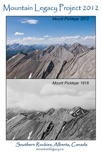
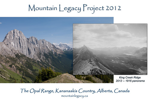
What gorgeous country we flew above and photographed! Here a few bests with their original photos (with doctoring from Mary) from those early stations:
Take a look at the following map that displays where we were in Kananaskis Country:
[googlemaps https://maps.google.ca/maps/ms?msid=218157135829958705070.0004c45bbeee9f6f61189&msa=0&ie=UTF8&t=m&ll=50.856243,-115.021362&spn=0.618979,1.234589&output=embed&w=425&h=350]
http://goo.gl/maps/8Hto
What a start to the field season!
A few snippets from our field notes from various stations, for a bit of flavour of the days:
“The GPS was bang on!”
“The weather is perfect and all photo angles line are lit up and clear.”
“In the distance, haze was starting to build!”
“Cairn spotted! What a great surprise to see that pile of stones last all these years.”
“Now we’re headed to get gas!”
“Again, there was a lichen-y cairn where the location was! Way to go, Nichols!”
PART TWO: Clearwater
We hit the road for a few hours drive north-west to the Shunda Fire Base, which is about 45 minutes due west of Rocky Mountain House. What a pretty base it was, with a strip of orange lilies, Indian paintbrushes of a colour range from deep red, almost purple-y, to light pale yellow, and a lot of cow parsnip! The helicopters parked right beside our lodgings. It was a delightful four day stay.
Unfortunately the weather pulled in, including dense fog, so we very sadly and reluctantly headed north! When the weather improves, we look forward to returning to the wonderful cooks and camp boss, and competent and friendly pilots, and welcoming fire-fighter crews! Here are a few key photos:

Jenna and Heike rephotographing a G. S. Malloch Survey shot from 1908. Our Station 26. That was a chilly day, that needed gloves and toques!

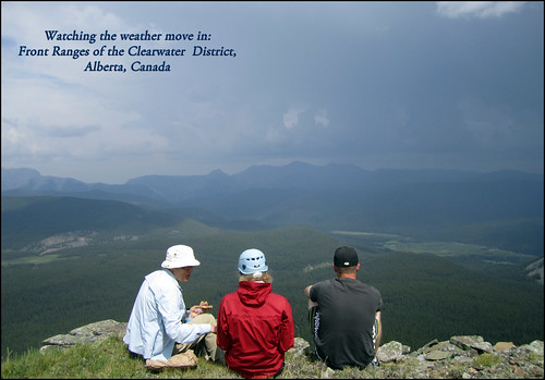
Lunching Mary and Heike with Pilot Cam! The soundscape was filled with thunder; some lightening dappled the undersides of the dark clouds.
The stations we achieved, and wanted to achieve linked here:
[googlemaps https://maps.google.ca/maps/ms?msid=218157135829958705070.0004c561624a72fd82545&msa=0&ie=UTF8&t=m&ll=52.510081,-116.590548&spn=0.3518,0.585732&output=embed&w=425&h=350]
http://goo.gl/maps/NXck
Also: this on our drive up to Grande Cache!! How beautiful:
PART THREE: The Willmore Wilderness
We just returned from our first two days in the Willmore Wilderness! What adventures we’ve already had! We hiked to two stations, and are returning to a third tomorrow. The pace here is a little slower: no helicopter support as of yet, so we can plan to hike to the closest ground stations.
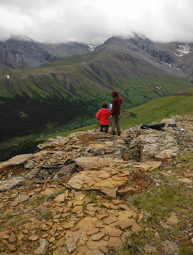
Our first station, number 11, we hiked to in about 3 hours, two days ago. We spent 45 minutes at the summit. Here are Jenna and Mary, lining up the shots:
This was the route we took: [googlemaps https://maps.google.ca/maps/ms?msid=218157135829958705070.0004c55ed63f4450c522d&msa=0&ie=UTF8&ll=53.496471,-118.17461&spn=0.025682,0.067978&t=m&iwloc=0004c55ee28402ffe15aa&output=embed&w=425&h=350]
We hiked through alpine meadows, stretches of lodgepole pine, and patches of stick-thin trembling aspen – their doubles-sided photosynthetic leaves flapping in the breeze that accompanied us.
Yesterday’s day saw us finishing an 18 kilometre hike from our Station 14. We left camp just after 9 AM, and returned at 9:30 PM. A shot from in the morning:
Here’s our route to this station:
[googlemaps https://maps.google.ca/maps/ms?msid=218157135829958705070.0004c55f28ce5bf8fb915&msa=0&ie=UTF8&t=m&ll=53.49785,-118.251343&spn=0.205451,0.543823&output=embed&w=425&h=350]
We had an encounter with a brief flash-flood incident at a river crossing that had us waiting for 2 hours for the water levels to recede as quickly as the rose. Here a shot of the rain:
During our wait, we encountered the most delightful company: Sarah and Mark Kelly, day hikers from the Edmonton area who were out with their family for a summer vacation! Here we are at the end of the day, so glad to be back at camp, packing up, and heading on our drive back to Grand Cache:

Back at Camp with Sarah and Mark!! They gave us a quick ride to our site. The ‘Chateau’ – our giant tent, in the background!
After facing hordes of mosquitos in the incredible sunshine, and a short but epic rain event, we return to Willmore tomorrow.
MORE COMING SOON!
MLP OUT:


