Mt. Robson and Mt. Assiniboine Provincial Parks: examining 100 years of landscape change


Introducing the Mt. Robson / Mt. Assiniboine Rephotography Project
Mountain Legacy Project: mountainlegacy.ca
May 31, 2019
Background
Based at the University of Victoria’s School of Environmental Studies, researchers with the Mountain Legacy Project (MLP) have spent the past 20 years using repeat photography to explore landscape change in the Canadian cordillera. Working with a vast systematic collection of historical mountain survey photographs – more than 120,000 are known to exist – MLP teams determine the photo locations, go to the same place, and accurately rephotograph the images. MLP researchers, drawn from sciences, humanities, arts, and environmental management, then find different ways to “let the photographs speak”. The same historic/modern pair will often tell different “stories”, depending on the questions asked and how they are framed. However, change – whether explicitly or implicitly climate-driven – is common to most.
The complete collection of historic images numbers more than 120,000, with approximately 90,000 of those taken in British Columbia. The work of the MLP has concentrated to date on the Rocky Mountains in Alberta (from of a total of approximately 15,000 historic images). Through the Living Lab Project and earlier work with Parks Canada in Kootenay National Park, we have completed more than 1,000 images in BC. They can be seen on MLP’s public facing website explore.mountainlegacy.ca but are literally a drop in the bucket: about 1% of the total collection for the vast mountainous regions of BC.
To date only a handful of MLP repeats come from what are arguably Canada’s most iconic Rocky Mountain areas – Mt. Robson Provincial Park and Mt. Assiniboine Provincial Park. MLP research teams have been on the ground in both parks repeating 24 images in Robson (2011, 2012) and 46 in Assiniboine (2010, 2017). Much more remains to be done – but, before repeats can be taken the historic images need to be sourced, digitized, and correctly accessioned in to MLP’s database and Explore website.
In 2018 BC Parks, through the Living Lab for Climate Change project, provided a grant to the Mountain Legacy Project to do just that – locate, digitize, and make available an additional 146 historic images in Mt. Robson Provincial Park and an additional 57 in Mt. Assiniboine.
Featuring interactive maps and image galleries this website provides an overview of progress thus far. As well, it provides a sample of the type of landscape cover analysis these historic/modern image pairs can deliver via MLP’s custom Image Analysis Toolkit.
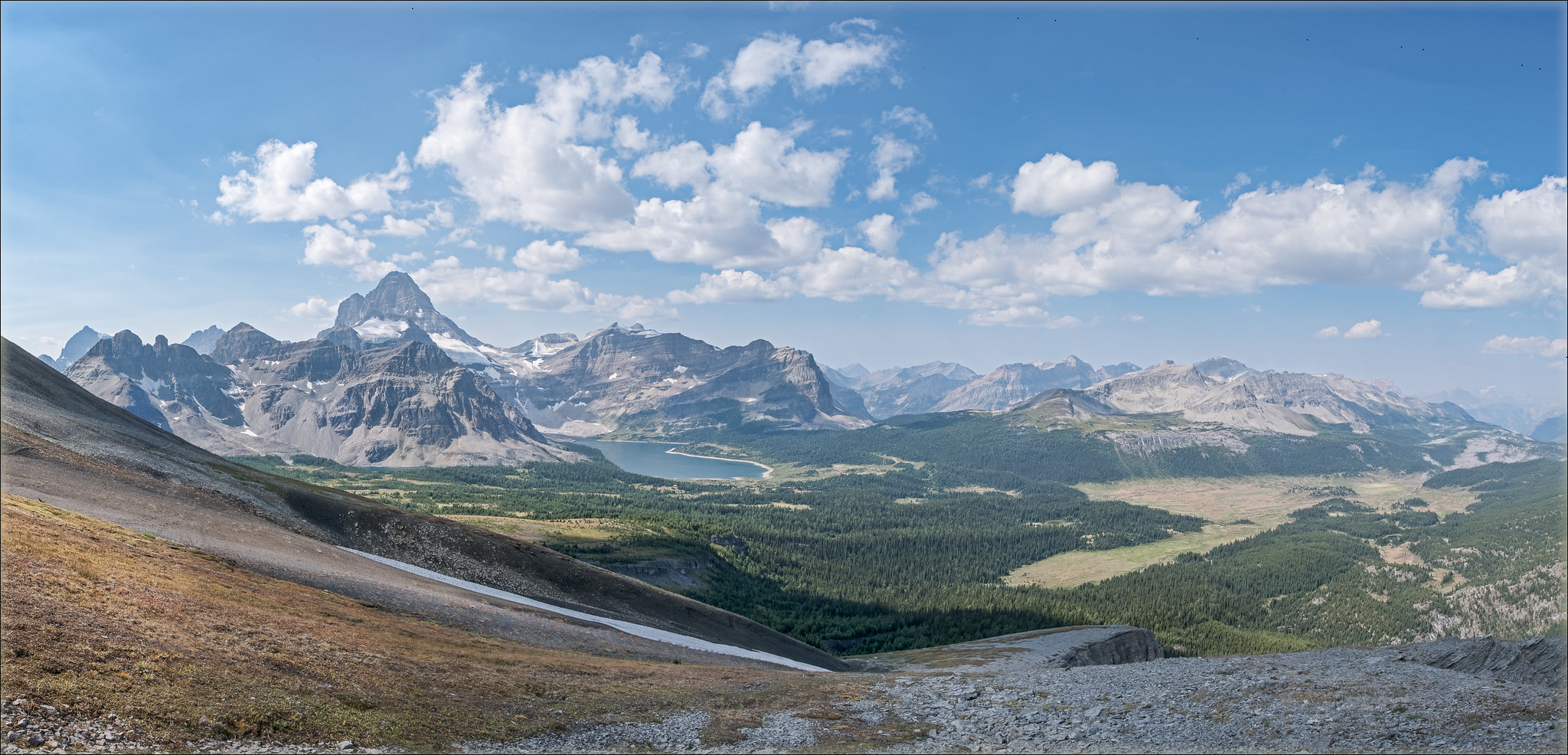
Mt. Assiniboine Provincial Park and images from the Inter-Provincial Boundary Survey
Background
From 1913 to 1927 survey crews undertook a huge project – mapping the boundary between British Columbia and Alberta. The project, named the Inter-Provincial Boundary Survey (IPBS), required resource commitments from the Federal government and the provinces of BC and Alberta. Alberta’s representative to the project was Richard William Cautley. He had the responsibility of surveying and marking the major passes along the border. BC’s representative was Arthur Oliver Wheeler, who was responsible for photo-topographical map making. This is a process that blends classic survey methodology with panoramic photography, allowing maps to show topographic features. It is the photo-topographical images that the Mountain Legacy Project seeks to repeat.
Wheeler and his team visited the Mt. Assiniboine area twice – once for several weeks in the fall of 1913 and again in the fall of 1916.
Jay Sherwood gives an excellent overview of the IPBS in this part of BC and Alberta in his book Surveying the Great Divide: The Alberta/BC Boundary Survey, 1913-1916.
Stations and images
The map below gives locations for all Wheeler IPBS stations on the ground in present-day Assiniboine Provincial Park. Click on it to open an interactive version.
Statistics for images in the Mt. Assiniboine area are as follows:
- 12 Station occupied in 1913 / 46 images taken / 46 repeated in 2010 and 2017.
- 6 Stations occupied in 1916 / 57 images taken / 18 repeated in 2017
As of 2019 all historic images have high-resolution copies available to MLP researchers and colleagues. Copies of all historic images and completed repeats are available online at explore.mountainlegacy.ca
Stations in Mt. Assiniboine Provincial Park

Surveyed by A. O. Wheeler and company in 1913 and 1916 as part of the Inter-Provincial Boundary Survey with repeats by MLP in 2010 and 2017. Click to open an interactive Google Map with links to each station.
View more historic/modern image panoramas taken in 2017 by MLP in Mt. Assiniboine Provincial Park: Re-photography in Assiniboine.
Mt. Robson Provincial Park and images from the 1911 Alpine Club of Canada / Smithsonian Institution Expedition
Background
In the summer of 1911 Arthur Wheeler led an ambitious expedition into Jasper Park, the Yellowhead Pass, and around Mt. Robson. As well as enjoying the support of the BC, Alberta, and Federal governments, the expedition was also backed by the Alpine Club of Canada and the Smithsonian Institution. The Grand Trunk Pacific Railway also contributed – as A. O. Wheeler says “handsomely to expenses”.
Key expedition goals were the collection of flora, fauna, and geology, and undertaking photo-topographical mapping.The team consisted of A. O. Wheeler, leader; Konrad Kain, guide; Byron Harmon, official photographer (but not the photo-topographical photographer – that role fell to Wheeler); Casey Jones, cook; Donald “Curly” Phillips, outfitter; George Kinney, assistant; Ned Hollister and J. H. Riley, United States National Museum, bird and flora collections; Charles Walcott Jr. and H. H. Blagden, hunters and big game collectors. They left Edmonton on July 1 and the last team members came out at Laggan (Lake Louise) on Sept 30, 1911.
In all 237 images were taken by Wheeler and company in the Mt. Robson area. They are, in many cases, the first photographs made in the area and reveal a stunningly diverse landscape from the valley of the Fraser River to close-up views of Mt. Robson – at 3,954 m the highest peak in the Canadian Rockies.
The story behind the images is a compelling one: A first person account from Arthur Wheeler, trail notes from George Kinney, and an account of getting everyone home again by Donald Phillips all appear in the 1912 edition of the Canadian Alpine Journal. 110 years of CAJ content is online and searchable – read the story of the 1911 Expedition in its pages.
Stations and images
The map below gives locations for all 1911 Expedition stations on the ground in present-day Mt. Robson Provincial Park. Click on it to open an interactive version.
Statistics for images in the Mt. Robson area are as follows:
- 35 Station occupied in 1911
- 237 images taken
- 4 stations repeated (3 in 2012, 1 in 2011)
- 22 repeat images taken
As of 2019 all 237 historic images have high-resolution copies available to MLP researchers and colleagues. Copies of all historic images and completed repeats are available online at explore.mountainlegacy.ca
Stations in Mt. Robson Provincial Park

Historic images from 1911 led by A. O. Wheeler. Repeats by MLP in 2011 and 2012. Click to open an interactive Google Map with links to each station.
View Mt. Robson Provincial Park image classification work undertaken by MLP in 2017/18 as part of a Living Lab grant at https://robsonlandscape.weebly.com/
Land cover analysis sample from Mt. Assiniboine Provincial Park
Image analysis background
For 20 years the Mountain Legacy Project (MLP) has been locating and repeating historic mountain photographs from the Canadian mountain west. These historic/modern image pairs can be analyzed and used in many ways – for example:
- show direct effects of climate change – especially in areas where direct human impact is negligible;
- identify areas of larger/smaller change;
- categorize and classify historic/modern landscapes;
- partner and augment other remotely sensed data;
- show historic and cultural evidence of Indigenous peoples on the land;
- allow the public to better understand extent of change.
MLP researchers have been working hard on software to help understand the image pairs and are pleased to offer the Image Analysis Toolkit as a resource for this purpose. The tool is still in development, but a sample of the type of analysis it can assist with is presented below.
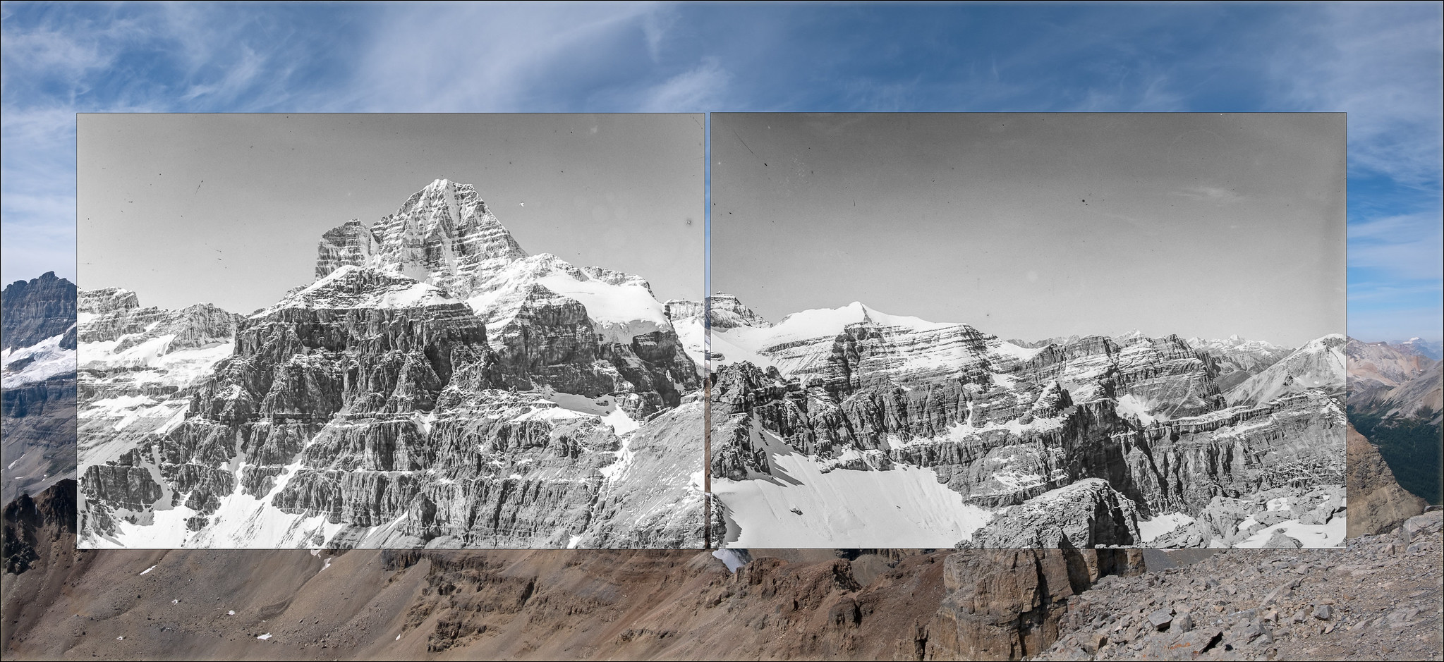
Mt. Assiniboine from below Nub Peak – a land cover change example
 Nub Station #1: 2017 |
 Nub Station #1: 1913 |
 Vegetation & Land Cover Classification Mask: 2017 |
 Vegetation & Land Cover Classification Mask: 1913 |
 Vegetation and Land Cover Classes |
|
The classification categories selected were arrived at in consultation with BC Parks ecologists. They were applied to images using the MLP’s web-based Image Analysis Toolkit. Certainly the loss of glacial ice in the intervening 104 years is noticeable. More startling, perhaps, is the homogenization of the land cover. The landscape captured in the 1913 images appears to be much more diverse in makeup than the same view in 2017. Dense coniferous forest seems to be infilling much of the mid-ground area in the photographs.
Using the land cover classification masks, IAT can quantify both the within and between image values for each class yielding a change matrix.

Change matrix showing the percentage of cover change between the 1913 and 2017 images taken from Nub Station #1.
As described in the change matrix, the Dense Coniferous class has increased 29%. IAT can also show where this change has occurred. The image below is a union of all areas classed as Dense Coniferous across the two images.

All Dense Coniferous areas across both images.
11% of the category remains unchanged between the two images – indeed, all of the 1913 DC class is encompassed in the 2017 class. 29.3% of the total Dense Coniferous category occurs in the 2017 image. A very small portion close to present day Magog Lake campground – less than 1% – occurs in 1913 and not in 2017. A recent publication by Fortin et. al. [1] suggests that over the past century this type of conifer densification appears to be occurring throughout Rocky Mountain landscapes.
Perhaps of more interest, especially to resource managers, is the ability to look backwards from 2017 to 1913 and answer the question “if it is dense coniferous forest in 2017, what was it in 1913”? IAT can provide a visualization to answer this question.

Dense Coniferous Forest category change from 2017 to 1913.
Going forward: Questions, comments, possibilities
Use of this type of image classification technique often raises a number of questions. Some of the key ones are as follows:
- Are the percentages in the images representative of similar percentages on the ground? Since these images are oblique “human-eye” views and not orthogonal “look-straight-down photos”, components in the landscape might be hidden by topography. However, if images look out over the landscape from a high vantage point (as the Nub Station No 1 images do) Fortin et. al. [1], and Rhemtulla et. al. [2], suggest that the percentages are very similar.
- Is it possible to geo-rectify the classifications, putting them on a 2D map or 3D DEM, and/or making them available as digital assets suitable for GIS work? MLP researchers have been devoting time to this issue for the past year. Challenges around geo-rectification are substantial, but the MLP team is cautiously optimistic that software designed to address the problem will be available in fall of 2019.
- This is only one photo pair – do the other photos taken in the Assiniboine area show the same type of conifer densification? What other changes/similarities are present? Nub Station No 1 is the only image pair MLP has analyzed in Mt. Assinboine Provincial Park. However, all 46 of the 1913 images have been repeated and at first glance conifer infill as well as up-slope movement of the Alpine Treeline Ecotone (ATE) is evident.Examine any of the Assniboine historic/modern image comparison online at explore.mountainlegacy.ca to see further evidence of forest infill. Panoramic images of historic and repeat images from stations within the park are available here: 2017 Re-photography in Mt. Assiniboine Provincial Park.
- What are some of the take-aways from this work that resource managers might find useful? As there are still many images to repeat and analyze in Assiniboine, perhaps the biggest take-aways are the questions raised with even just this one historic/modern image pair analysis. The ability to have a vegetation classification map for a landscape as it existed 100 years ago offers interesting possibilities – especially in a warming world where wildfire mitigation strategies are becoming more and more important. Historic images, their modern repeats, and land cover change data can help address some pressing questions. For example – How prevalent was fire on historic mountain ecosystems? How, if at all, did it help shape the landscape? What role, if any, did anthropogenic burning play? Do we see evidence of such burning on the landscape? Could restoring the “patchy” landscape diversity visible in the historic images play a mitigating role in light of increasingly severe wildfire regimes in the Canadian mountain west?
With so many interesting questions to pursue, Mountain Legacy researchers are keen to work further with BC Parks and the Living Lab Project.
[1] J. A. Fortin, J. T. Fisher, J. M. Rhemtulla, and E. S. Higgs, “Estimates of landscape composition from terrestrial oblique photographs suggest homogenization of Rocky Mountain landscapes over the last century,” Remote Sensing in Ecology and Conservation, 2:100, Dec, 2018. Available: http://cie.ed.asu.edu/volume6/number12/. [Accessed May 31, 2019].
[2] J. M. Rhemtulla, R.J. Hall, E.S. Higgs, and S.E. Macdonald, “Eighty years of change; vegetation in the montane ecoregion of Jasper National Park, Alberta, Canada.” Can. Journal of Forestry Resources, 32: 2010–2021, 2002. Available: https://www.nrcresearchpress.com/doi/abs/10.1139/x02-112#.XQLp1Y97laR. [Accessed May 31, 2019].
Historic Image Galleries from the Mt. Robson and Mt. Assiniboine Areas
Mt. Robson panoramas from 1911
Historic images from the Alpine Club of Canada / Smithsonian Institution’s 1911 expedition to map and explore the area around Mt. Robson. The expedition was led by Arthur Wheeler – surveyor, map-maker, and first president and co-founder of the Alpine Club of Canada.
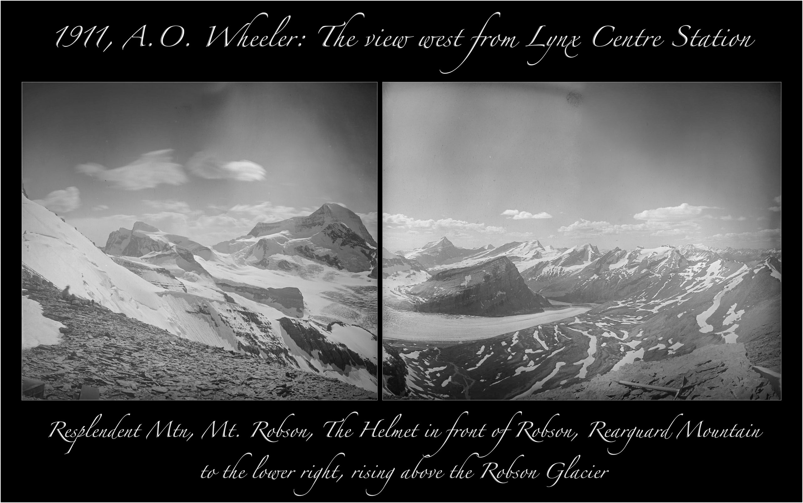
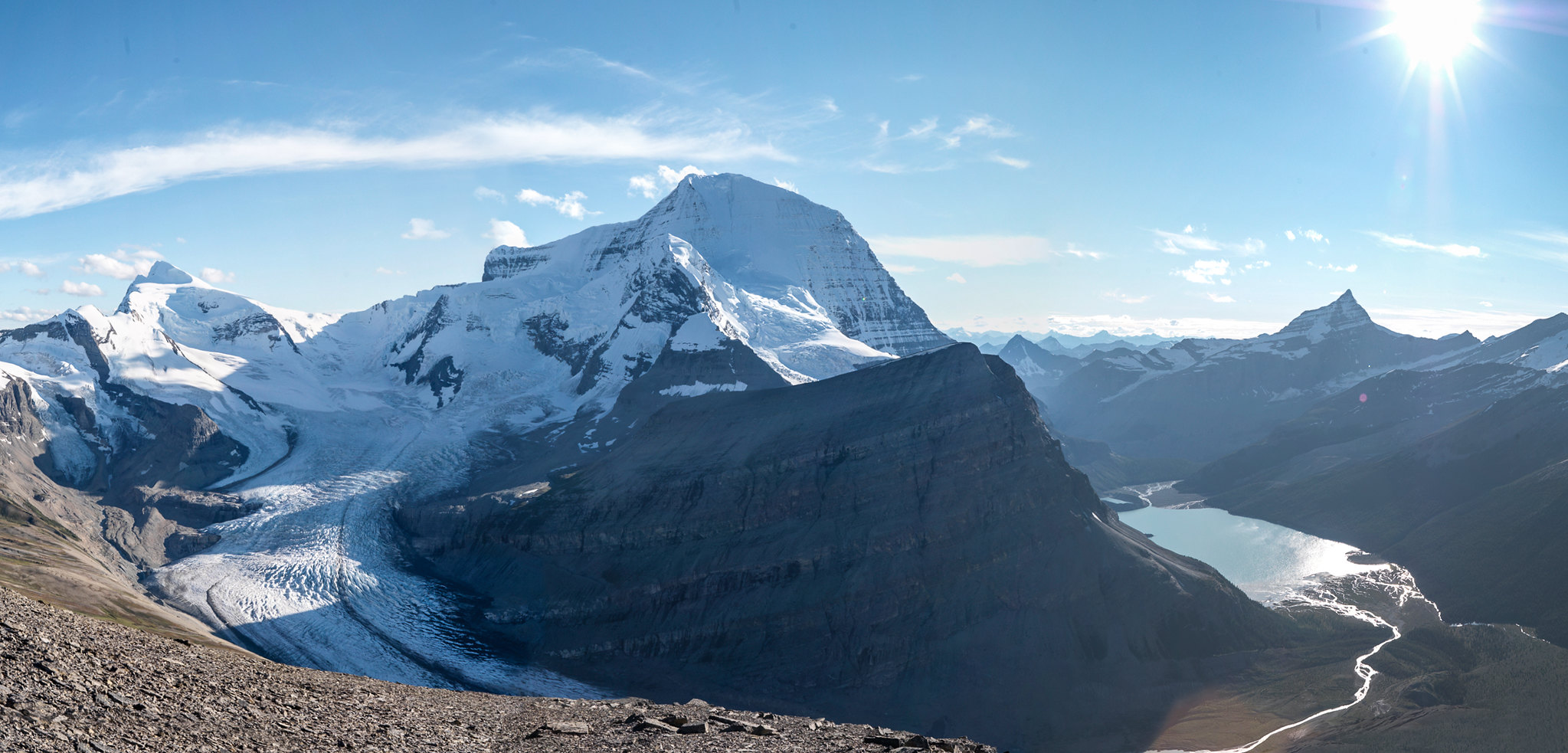
Lynx Centre Station looking over Mt. Robson and the Robson Glacier – A. O. Wheeler, 1911
Wheeler in his notebook records this view as “So stupendous, so superb, so unexpected was it that we were struck dumb with amazement.”
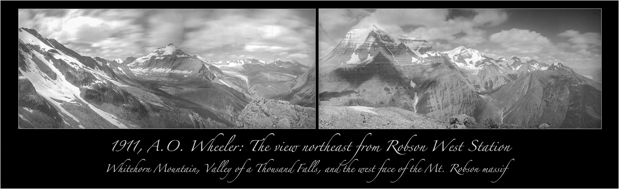
Robson West Station: A. O. Wheeler, 1911
The view northeast from Robson West Station – Whitehorn Mtn, the Valley of a Thousand Falls (today’s Berg Lake Trail), and the west face of the Mt. Robson massif.
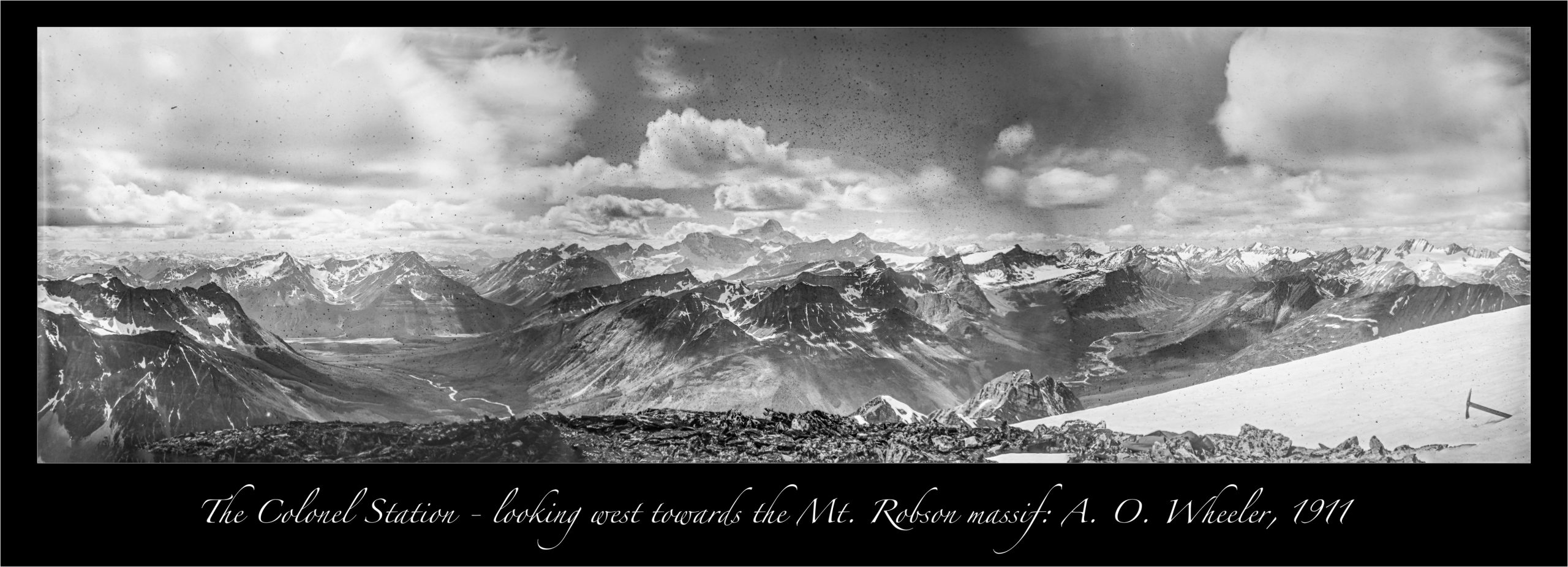
The Colonel Station – A. O. Wheeler, 1911
A high peak standing almost alone in the valley of the Moose River – it commands wonderful views of the area.
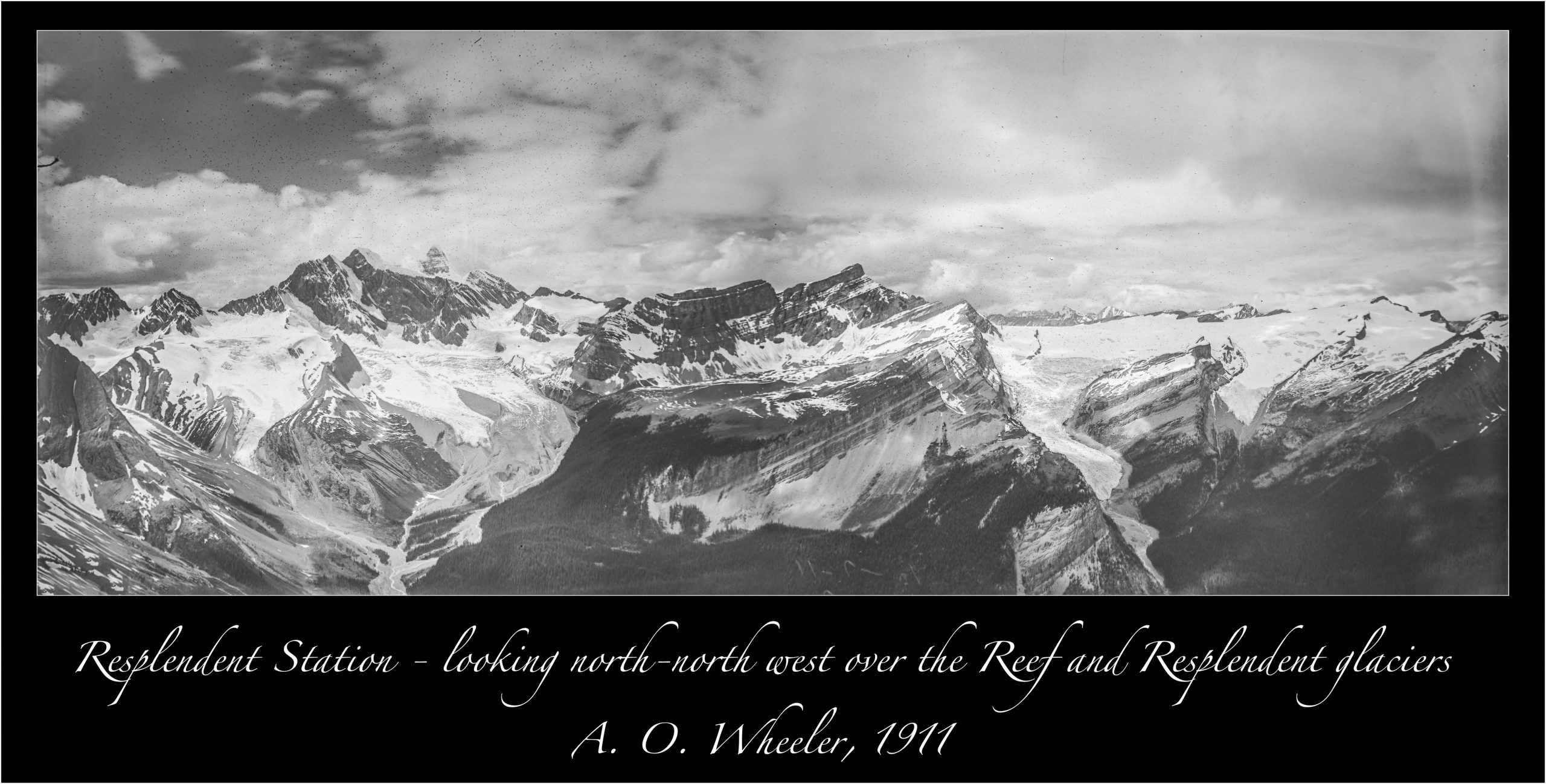
Resplendent Station looing north-north west – A. O. Wheeler, 1911
Views over the Reef Icefields, Mt. Robson, and Lynx Mountain. Resplendent Mountain itself is seen in the middle left of the image.
More historic panoramic images from Mt. Robson Provincial Park are available via the Robson Historic Panoramas gallery. Images have interactive annotations embedded into the photo. Click on an image of interest and move the mouse over it when the full sized photo appears. Annotations will emerge over selected image features.
Mt. Assiniboine panoramas from 1913 and 1916
Historic images from the early years of the Inter-Provincial Boundary Survey between British Columbia and Alberta. Arthur Wheeler was responsible for the photo-topography component, hence the many historic images from the continental divide that makes up the BC/Alberta border.
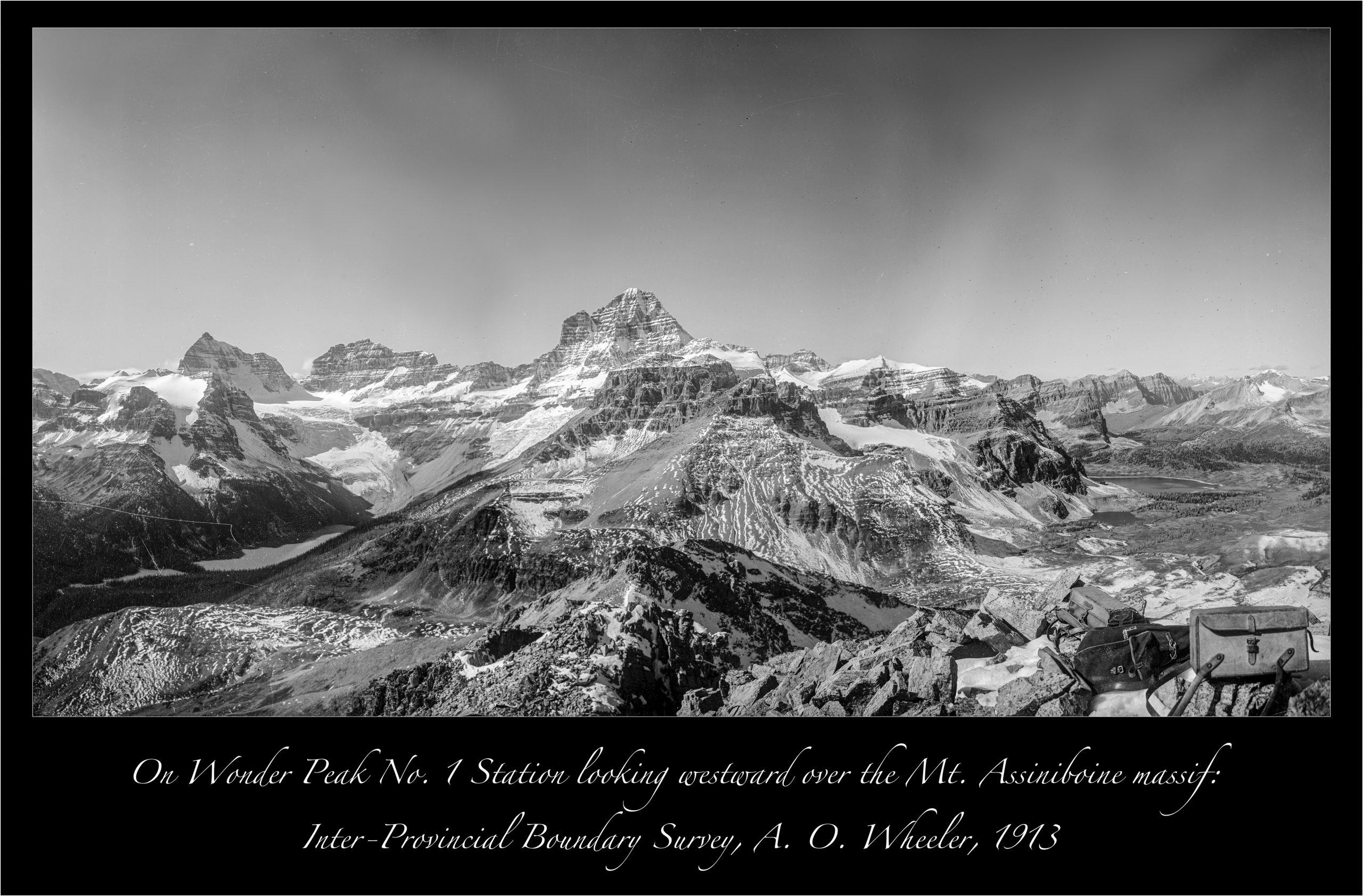
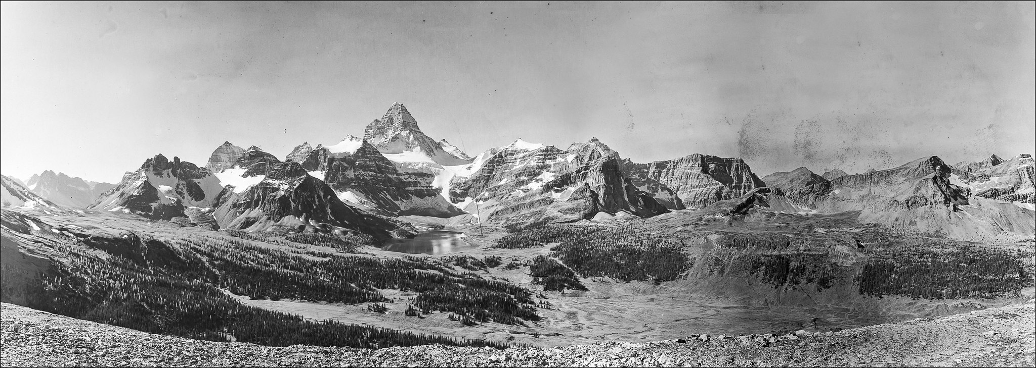
Wonder Peak No 1 Station: A. O. Wheeler, 1913
The entire of the Mt. Assiniboine massif is seen in this 1913 image from the west ridge approach to the Wonder Peak.
B&W insets – The Towers Station: A. O. Wheeler, 1916
On The Towers looking westward pver Terrapin Peak to Mt. Assiniboine and Lunette Peak.
On Cave Mountain: A. O. Wheeler, 1916
Views of Mt. Assiniboine and the Magog Lake area from below the summit of Cave Mountain.
Mt Assiniboine massif – A. O. Wheeler, 1916
The Mt. Assiniboine massif from the north ridge of Mt. Cautley.
More historic panoramic images from Mt. Assiniboine Provincial Park are available via the Assiniboine Historic Panorama gallery. Images have interactive annotations embedded into the photo. Click on an image of interest and move the mouse over it when the full sized photo appears. Annotations will emerge over selected image features.
Project Researchers

Mary Sanseverino
Research Associate - Mountain Legacy Project
Mary is an Assistant Teaching Professor Emerita in the Department of Computer Science at UVic. In 2010 she was honoured with the University of Victoria’s Harry Hickman Alumni Award for Excellence in Teaching and Educational Leadership.
A long time mountaineer and photographer, Mary’s other research interests have involved work with computational photography, making her a good fit with the Mountain Legacy Project. She has been associated with the project since 2010, going out into the field every year since 2012. Contact Mary at mntnlgcy@uvic.ca

Eric Higgs
Mountain Legacy Project Principal Investigator
Eric’s research interests combine ecological and philosophical methods and insights to understand how we intervene responsibly in ecosystems experiencing rapid change. The change is not just environmental and ecological; it is cultural, too. For almost two decades he has operated the Mountain Legacy Project, a long-term study of changing Canadian mountain landscapes using the world’s largest systematic collection of historical survey photographs.
More about Dr. Eric Higgs at www.erichiggs.ca

Hanna Schmidt
Undergraduate Research Assistant
Hanna is a Civil Engineering undergrad student at UVic. Before going back to school, she spent time cooking at backcountry ski and hiking lodges and developed a passion for exploring and sharing remote mountain experiences. Hanna has worked with the Mountain Legacy Project as a research assistant for the past year. She has accessioned images into MLP’s databases, segmented and classified images, and helped in image analysis.
Research Sponsors and Collaborators


