Muskwa-Kechika and the Finlay River: Looking back to look forward
Introducing the Muskwa-Kechika / Finlay River Rephotography Project
Mountain Legacy Project: mountainlegacy.ca
Mar 1, 2019

Map of the Muskwa-Kechika / Finlay River – Williston Lake reservoir area.
Background
Based at the University of Victoria’s School of Environmental Studies, researchers with the Mountain Legacy Project (MLP) have spent the past 20 years using repeat photography to explore landscape change in the Canadian cordillera. Working with a vast systematic collection of historical mountain survey photographs – more than 120,000 are known to exist – MLP teams determine the photo locations, go to the same place, and accurately rephotograph the images. MLP researchers, drawn from sciences, humanities, arts, and environmental management, then find different ways to “let the photographs speak”. The same historic/modern pair will often tell different “stories”, depending on the questions asked and how they are framed. However, change – whether explicitly or implicitly climate-driven – is common to most.
As of 2018 the Mountain Legacy Project has rephotographed over 8000 historic images and made them, along with many more as yet unrepeated images, available on MLP’s public education and outreach site: explore.mountainlegacy.ca. The majority of both the historic images and their repeats come from the Rocky Mountains in Alberta. As well, almost 100% of the historic images used thus far are held by Library and Archives Canada – a key MLP research partner – at the Preservation Centre in Gatineau, Quebec. However, the Royal BC Museum and Archives also has an extensive and well-maintained collection of historic mountain survey photographs – over 21,000 images in the photo-topographical map making survey collection alone. These images and their supporting meta-data span the years 1901 – 1976. MLP has long wanted a chance to examine these images and see if they might be used for repeat photography.
What might make a fitting project to tap into this rich BC-based historic resource? In late 2017 MLP researchers advanced an ambitious project to explore over 3000 glass plate negatives laid down from 1939 – 41 by surveyors working in the Muskwa-Kechika / Finlay River region shown on the map above.
Muskwa-Kechika / Finlay river study area
This huge area draining landscapes that form the northern Rocky Mountains is known by many as the “Serengeti of the North”. It is a landscape that has experienced direct human-induced change at an ecosystem level – the Bennett Dam and creation of Williston Lake reservoir. Forestry and some mineral resource extraction are also practised here. However, an examination of the map above shows a wilderness area with few roads and little large-scale infrastructure – an area where landscape change, if it is detectable, might be more unambiguously examined for signs of climate change at work in mountain environments.
In 2018 BC Parks, through the Living Lab for Climate Change project, provided a grant to the Mountain Legacy Project to begin working with historic photos from the Muskwa-Kechika / Finlay River / Williston Lake area. MLP research associates Dr. Joy Davis and Mary Sanseverino met with archivists and administrators at the Royal BC Museum and Archives and a rich trove of photos, maps, and accompanying meta-data was uncovered and made available for study.
This website reports on the resources, history, and further research and collaborative potential at the BC Museum and Archives revealed through these amazing images.
Muskwa-Kechika / Finlay River: A brief historical background
By Dr. Joy Davis, MLP Research Associate
Mountain Legacy Project: mountainlegacy.ca
Mar 1, 2019
Introduction
The Muskwa-Kechika – Finlay River Repeat Photography project, undertaken as part of the University of Victoria’s Mountain Legacy initiative (mountainlegacy.ca), locates and digitizes photo-topographic images and other resource materials generated by survey activity within and adjacent to the Muskwa-Kechika Conservation area in British Columbia in the period 1939-1941. As a subsequent step, it undertakes repeat photography in selected locations and analyzes change in the landscape over the intervening years. The project focuses on the portion of the inter-montane Rocky Mountain Trench that bisects north-eastern British Columbia. The mountainous terrain defines the region’s character, ecology, history, use and significance. With its abundance of wildlife and remarkable biodiversity the area is “one of the last great remnants of the vast wilderness that once existed across North America” (Tourism Northern Rockies, n.d.).

Northern Rocky Mountain Trench and Sifton Pass. Click the map to open a large Google Map of the area.
The Trench, which runs for over 1600 km in a north-south alignment along the western slopes of the Rocky Mountains, was described by R.G. McConnell of the Geographical Survey of Canada in 1893 as one of the province’s “most important topographical features” (as cited in Gunderson, 2000, p. 10). It varies from three to sixteen kilometres in width. The only river that crosses the Trench, running east through the Rockies to the McKenzie drainage basin, is the Peace. This defines the southern boundary of the region. North of the Peace, the relatively flat corridor of the Trench and its adjacent watersheds has been home to the Kaska Dena, Treaty 8, and Tse’khene peoples for millennia.The Kaska Dena refer to the Trench as the Ihts | Zele Tsetiah Corridor which means Warm Wind Valley. The Atse Dena Tunna or the “Path of the Ancient Ones” connects scattered Kaska Dena communities (Gunderson, 2000, p. 5). It is postulated that the Trench was one of the important “southward migration corridors for settlement of North America in the vicinity of 10,000 – 14,000 years ago” (Gunderson, 2000, p. 1). And over the past two centuries it has provided an access route for explorers, prospectors, settlers and government agencies seeking to move people and goods into the region and beyond to the Yukon and Alaska.

Portion of Mckenzie Basin Map, Wikipedia.com
A network of rivers meander through vast Trench watersheds. In the northern-most part, the Kechika River collects waters from the Gataga and Turnagain Rivers that have their beginnings in the mountainous terrain to the north of Sifton Pass (3320 ft). The Kechika connects with the Liard River drainage system that flows into the McKenzie and on to the Arctic Ocean. South of Sifton Pass, the Fox, Kwadacha and Ingenika Rivers join the Finlay River, flowing southward to intersect with the Parsnip River to become the Peace River that also feeds into the Mackenzie River basin.
White settlement and exploration
Given the remoteness of this area, European traders, prospectors and settlers were slow to make their way into the valleys that had long been occupied by First Nations. The first exploratory expedition was led by Alexander McKenzie in 1793, moving west along the Peace River, then south along the Parsnip and eventually to the Pacific at Bella Coola. John Finlay, a member of this expedition, returned to the area in 1797 to follow what became his namesake river northward from its confluence with the Parsnip. Records indicate that he followed ‘Finlay’s’ River to its junction with the Ingenika, 130 km north. The map he prepared is referenced by Samuel Black in 1824, but has disappeared. Black, a trader with the Hudson’s Bay Company, followed Finlay’s footsteps, moving beyond the Ingenika to the headwaters of Finlay river at Thutade Lake. In 1877 a HBC fort was established at Fort Grahame near the confluence of the Parsnip and Finlay Rivers. Subsequent exploration along the Finlay and its tributaries, over Sifton Pass and north along the Kechika River took place in the final decades of the 19th Century. Mineral deposits attracted a number of prospectors and miners and prompted the Canadian Geological Survey to send R.G. McConnell out to map the Finlay and its tributaries in the summer of 1893. During these years, a handful of settlers also tried ranching and trapping to eke out a living. R.G. McConnell, of the Geological Survey, spent the season of the 1893 on the Finlay and its tributaries. And in 1897 The North-west Mounted Police improved and patrolled traditional pathways through the region for the many ‘Overlanders’ making the difficult trip to Yukon gold fields along what had come to be known as the Davie Trail. Further work on trail development took place in 1906 and 1907 (McKenzie Museum, 2016).
Early 20th century government interest
Provincial government interest in this large and undeveloped area of British Columbia picked up in the early decades of the 20th century as the construction of the Grand Trunk Pacific Railway (later the Canadian National Railway) through Prince George, over 300 km to the south, brought new settlers and entrepreneurs closer to the region. Recognizing the need for land surveys to support development and land sales, the newly formed Surveys Branch of the BC Department of Lands commissioned Mr. A.W. Harvey to survey along the Finlay as far as Deserters Canyon (Province of British Columbia, 1940, p. 31) in the summer 1912. In the same year, B.C. Affleck surveyed parts of the Liard area and ventured along the Kechika River, which he described as “perhaps the most beautiful valley in all of Northern British Columbia” (Gunderson, 2000, p. 12). The open, relatively level nature of the region was beginning to be identified as a potential railway or roadway route at this time.
The following year, Frank C. Swannell commenced three summers of fieldwork along the Finlay (1913, 1914, 1916), building on the exploratory work he had already done in the Cassiar area. The Surveyor General provided the following instructions:
“I am directed by the Honourable the Minister of Lands to instruct you to continue your Exploration Surveys of last season. I have much pleasure in informing you that your work of last year meets with the approbation of the Department and in view of the success you obtained in these operations it would appear to be hardly necessary to give you definite instructions.
You will continue your rough triangulation to the North and East. There is one matter, however, to which I wish to call your attention. It is neither necessary or possible in a triangulation such as you are making to obtain results of extreme accuracy, your work being in the nature of an Exploratory Triangulation. Such being the case I must impress upon you the necessity of covering a large area of country rather than looking for refinement in the point of accuracy.
With one exception you are the only surveyor employed by this Department on exploratory work. It is therefor a matter of some importance that the area covered by you be large, the filling in of such detail, such as lake (?) traverses can be done at some future date. … I wish you to bear in mind that the Department wish a preliminary knowledge of a large section of country rather than a comparatively correct triangulation of a limited area. ” (Swannell, 1914, pp. 125, 127)
Swannell returned to the Finlay on a number of occasions over the next two decades. In the 1930 and ’32 field seasons he continued his work on the Ingenika River, including some surveying associated with the Ingenika Mine, and he made his way to the headwaters of the Finlay River at Thutade Lake in the Omineca Mountains. He was working alongside surveyors seeking to tie the area into the British Columbia Government triangulation net, based on geodic survey positions at Prince George. He also spent the summer of 1934 in the region, accompanying the Bedeaux Expedition and mapping its westward progress upstream on the Muskwa and Kechika Rivers, then south over Sifton Pass and down the Finlay and Peace Rivers. He returned in 1935 to complete his triangulation work in the Finlay and Parsnip regions (Province of British Columbia, 1936, p. 33).
Intensive surveying activity took place from 1939 to 1941 when the Province gave precedence to finding a BC-based route for the Alaska Highway to meet wartime transport needs, as noted in the Surveyor General’s Annual Report (Province of British Columbia, 1940, p. 13).
The US Military also undertook a cursory investigation of the area as a potential railway route in this period. According to surveyor and author R.G. Harvey, it conducted a 500 mile railway survey from Prince George to Lower Post along the Parsnip and Finlay valleys. It cost $2 million dollars, but came to nothing (as cited in Gunderson, 2000, p. 14).
Despite extensive surveying along the northern section of the Rocky Mountain Trench, a decision was made in 1942 to route the Alaska Highway project to the east, and subsequent development of this part of the Province was limited to mining exploration and development and to the infrastructure of the massive W.A.C. Bennett dam, constructed between 1961 and 1968 to generate power for the Province. This project irrevocably altered the landscape of the Trench upstream on the Peace River, flooding significant portions of the valleys of the Finlay and Parsnip to create Williston Lake.
Today much the Rocky Mountain Trench east and north of Williston Lake, including fifty intact watersheds, has been protected within the Muskwa-Kechika Wilderness area, established by the Province of British Columbia “to maintain in perpetuity the wilderness quality, and the diversity and abundance of wildlife and the ecosystems on which it depends while allowing resource development and use in parts of the Muskwa-Kechika Management Area designated for those purposes including recreation, hunting, trapping, timber harvesting, mineral exploration and mining, oil and gas exploration and development”(“Muskwa-Kechika Management Area Act,” 1998). At 6.3 million hectares the M-K is one of the largest wilderness areas in North America, below the 60th parallel (Sawchuk, 2004). It has national and global significance for its ecological values.
References
Gunderson, E. (2000). Management Plan Continuation for the Southern Davie Trail with Historical Background. Retrieved from http://www.mackenziemuseum.ca/wordpress/wp-content/uploads/Gunderson-2000-Kaska-Davie-Trail-Report.pdf
McKenzie Museum. (2016). Centuries of Travel on the Davie Trail. Retrieved from http://www.mackenziemuseum.ca/the-davie-trail/
Muskwa-Kechika Management Area Act, Legislative Assembly of the Province of British Columbia, SBC 1998 Chapter 38 Stat. (1998).
Patterson, R. M. (2011). Finlay’s River (Kindle ed.). Victoria: Touchwood Editions.
Province of British Columbia. (1936). Annual Report of the Lands and Survey Branch of the Department of Lands (1935). Victoria: Legislative Assembly Retrieved from https://www.for.gov.bc.ca/hfd/Library/Annual/DoL_LS_AR1935.pdf.
Province of British Columbia. (1940). Annual Report of the Lands and Survey Branch of the Department of Lands (1939). Victoria: Legislative Assembly Retrieved from https://www.for.gov.bc.ca/hfd/Library/Annual/DoL_LS_AR1939.pdf.
Sawchuk, W. (2004). Muskwa-Kechika: The wild heart of the Canadian Rockies. Chetwynd, BC: Wayne Sawchuk.
Swannell, F. C. (1914). Journal, Finlay River Survey. Surveyor General, BC Department of Lands.
Tourism Northern Rockies. (n.d.). Muskwa-Kechika Retrieved from https://www.tourismnorthernrockies.ca/listing-item/muskwa-kechika/
Overview of Early 20th Century Land Surveying in the
Muskwa-Kechika / Finlay River Area
By Dr. Joy Davis, MLP Research Associate
Mountain Legacy Project: mountainlegacy.ca
Mar 1, 2019
The British Columbia Surveys Branch was formed in 1911 to better organize surveying activities that had been the responsibility of British Columbia’s Department of Lands and Works since its creation in 1871. The Topographic Division of the Surveys Branch was created in 1929 with the primary responsibility of providing data for map making. A description of their approach to the photo-topographic surveying methods typically used alongside triangulation methods to survey much of British Columbia is noted in the description of surveying fonds held in the Public Archives of British Columbia (https://search-bcarchives.royalbcmuseum.bc.ca/photo-topographical-survey-records):
….“The photo-topographical survey method of mapping was described by R.E. McCaw, B.C.L.S. as follows: “In the mountainous areas of Western Canada, the photo-topographical method for obtaining a topographical map has been used for many years. A triangulation of a fair degree of accuracy is necessary for a base. Rounds of photographs, by specially designed survey camera are taken from the triangulation stations, and many other independent stations which are all connected into a net work of control which may be plotted to scale. It is essential to have all portions of the landscape photographed from two or more different points, which are usually on the summits of mountains or high ridges. The camera is always set in a carefully levelled position. In the office, enlargements from the photographic negatives are made. The directions of these are plotted and points identified from views from adjacent stations overlooking the same area. Using the principles of descriptive geometry and perspective, these points are plotted and the elevations computed. It is always the endeavour to choose the points in such a way they will outline streams, lakes, ridges, etc. Rivers, creeks, lakes, roads, etc., are then drawn in using the photographs as a guide. The slope is then shown by contours, the accuracy of all depending upon the accurate instrumental work in the field and the number of identified points used in the office.”

Triangulation points prepared by Frank Swannell, BCLS. Click to enlarge the photo.
The above map of triangulation points from which 1939 photo-topographical surveys were conducted was prepared by F.C. Swannell, British Columbia Land Surveyor (BCLS) as a basis for the work in the Rocky Mountain Trench north of Finlay Forks (and the current Williston Lake Reservoir). It serves as a important reference in the process of identifying the points at which photo-topographical images were recorded in the 1939-1941 surveys that are the basis of this project.
As noted, comprehensive and detailed triangulation, aerial and photo-topographic surveys were conducted beginning in 1939 as a basis for identifying a British Columbia route for the proposed Alaska Highway. Given the pressure from the United States to construct this highway for military purposes, the Surveys Branch of the BC Department of Land devoted considerable resources to this survey initiative, with the bulk of the work taking place in 1939, building on earlier exploratory surveys in the region.
BC Land Surveying timeline in the Muskwa-Kechika / Finlay River area
| Area | Surveying prior to 1939 | 1939 Field Season | 1940 Field Season | 1941 Field Season |
| Rocky Mountain Trench, north of Finlay Forks | Aerial photography of the portion south of Sifton Pass by G.S. Andrews of the Dept of Lands at an elevation of 16,000 ft.
Photo-topographic views were taken and angles read from fifty-one stations; ten of these were on cut-banks along the river, the rest were on mountains on each side of the valley. All stations were marked by iron bars or brass bolts. |
Aerial photography north of Sifton Pass completed by Jack Benton of the Dept of Lands | ||
| Finlay Forks to Deserters’ Canyon | McCaw, surveyed from Finlay Forks to Deer Creek | |||
| Ingenika River | LeRoy Cokely and FC Swannell laid out a base for triangulation control at the confluence of the Ingenika and Finlay Rivers in the summer of 1930 and did a triangulation survey of the Ingenika River. | Swannell reaffirmed initial base for triangulation in support of the overall 1939-41 project. | Chief Toma and Arthur Tuttle (federal land surveyor??) surveyed the Ingenika area in 1941 | |
| Deserters Canyon to Fort Ware | Campbell: Undertook photo-topographic (PT) survey from Deer Creek to Rubyred Creek | |||
| Headwaters of the Finlay River | Jackson: lead a PT survey from Rubyred Creek to Paul Creek | |||
| Fort Ware along the Fox River to Sifton Pass | Stewart: Led a PT survey from Paul Creek to Sifton Pass | |||
| Kechika River to Turnagain River | Hugh Pattinson focussed on establishing points on mountain peaks at Sifton and Scarcity as the basis for the triangulation network north on the Kechika | Hugh Pattinson led a triangulation survey from Sifton Pass along the Kechika and then along the Turnagain Rivers. In the same season, NC Stewart conducted a PT survey from Sifton Pass to 55 miles NW along the Kechika. | AJ Campbell continued PT surveying from the point at which Steward ended, covering a further 65 miles to the Earle River. At the same time, NC Steward mapped the area from Earle River to the northern boundary. | |
| Liard River to Lower Post | Philip Monckton led a triangulation survey on the Kechika and Liard Rivers | Phillip Monckton continued his survey south from Liard to the mouth of the Turnagain River |
Image and metadata assessment
Mountain Legacy Project: mountainlegacy.ca
Mar 1, 2019
Image analysis background
For 20 years the Mountain Legacy Project (MLP) has been locating and repeating historic mountain photographs from the Canadian mountain west. These historic/modern image pairs can be analyzed and used in many ways – for example:
- show direct effects of climate change – especially in areas where direct human impact is negligible;
- identify areas of larger/smaller change;
- categorize and classify historic/modern landscapes;
- partner and augment other remotely sensed data;
- show historic and cultural evidence of Indigenous peoples on the land;
- allow the public to better understand extent of change.
However, the start of all these visualization and analysis modalities begins with an assessment of the historic imagery. Therefore, the goal of the Muskwa-Kechika / Finlay River Rephotography Project is to work with the Royal BC Museum and Archives to examine approximately 3000 glass plate negatives from this remote area to see if they are suitable for rephotography. The plates, which are in excellent shape, were taken by four British Columbia Land Surveyors (BCLS) during the 1939 – 41 field seasons in landscapes within and alongside BC’s northern Rocky Mountains.
The photo-topographic survey method uses photography, along with traditional survey techniques, to make topographic maps of an area. The BC Land Surveyors of interest to this project are Alan John Campbell, BCLS #101; George John Jackson, BCLS #74; Robert Daniel McCaw, BCLS #95; and Norman Charles Stewart, BCLS #120. The land they traversed is today part of the Williston Lake Reservoir, the valleys of the Finlay, Fox, Ketchika, Gataga, and Turnagain rivers, and the mountains and high points to either side of these features.
Analysis area
The Surveyors and Survey Seasons map on this page gives an approximation of the area covered by each surveyor over the years 1939-41. 1939 was a particularly busy season in the region!

Surveyors, survey seasons, and an approximation of how much land they covered in a given season.
The number of “stations occupied” (locations where surveyors took images from) and number of “plates exposed” (pictures taken – these were black and white negatives on 6 inch x 4 inch glass plates) per surveyor per season are as follows:
- Robert Daniel McCaw (1939) – 30 stations occupied, approximately 350 plates exposed;
- Alan John Campbell (1939) – 47 stations occupied, approximately 450 plates exposed;
- George John Jackson (1939) – 50 stations occupied, approximately 400 plates exposed;
- Norman Charles Stewart (1939) – 63 stations occupied, approximately 600 plates exposed;
- Norman Charles Stewart (1940) – over 65 stations occupied, approximately 700 plates exposed;
- Alan John Campbell (1941) – 35 stations occupied, approximately 350 plates exposed.
This gives approximately 2850 plates from the areas shown in the map above. Other surveys up towards the Liard River and along some of the Muskwa River were also undertaken, but images from these areas have not as yet been examined.
The initial goal of this project was to work with glass plates held at the Royal BC Museum and Archives and assess them for potential rephotography. However, after consulting with Ember Lundgren, Preservation Manager for the Archives and RBCM Operations, the project was gifted with an outstanding find – several years ago the Land Title and Survey Authority of British Columbia moved a number of records into the BC Archives. Amongst all of these records were enlarged black and white print photographs matching many of the 1939-41 plates. These photos were in “occupied” station order and were marked up with place names, surveyor information, and plotting notation – an exciting metadata find that MLP researchers have not had the opportunity to work with before.
As well as the printed photos, maps containing the triangulation grid with station names corresponding to the names on the photos were also accessioned in to the Archives. A final set of records – almost the icing on the cake – includes lists of the accurate location positions (latitude/longitude) for all of the stations. Again, the station names match those on the maps and the printed photos. Working with the additional data has slowed the project down, but what a welcome slow-down it has been! This “value added” will help MLP researchers place the images into geographic context with a finer degree of ease and accuracy than is usual.
The gallery of photographs below shows each type of artifact. It gives a sense of how they join together to give a full picture of not just one station, but the entire systematic operation that photo-topographic surveying entails.
Detailed assessment of all data for the 1939 season is complete, and a rapid appraisal of the 1940 and 41 material has been undertaken. The negatives are in excellent condition and, with the additional latitude/longitude data, all of the stations are easily located. The historic images of the Muskwa-Kechika / Finlay River area would make excellent candidates for rephotography.
Example of survey artifacts from Station Omega, A. J. Campbell, 1939
Click the images to enlarge

Example of a glass plate negative. This is what the images look like on the glass plate. The numbers in the upper right indicate that this was the 2nd plate taken from Box 31 in A.J. Campbell’s 1939 field season.

Example of a glass plate negative turned into a positive. The numbers in the upper right indicate that this was the 2nd plate taken from Box 31 in A.J. Campbell’s 1939 field season.

Example of a positive, enlarged print made from the negative glass plate. The view here is north east across the Finlay River. Notice how a plotting cross hair is drawn on the image. Also, Chowika Peak is noted, as is Police 2. Both Chowika and Police are also stations in the triangulation grid. The numbers 2-31 C39 in the upper right stand for the 2nd glass plate out of box 31 in Campbell’s 1939 season. The number written below, 2357 in this case, is the adjusted elevation of the station in feet.

Example of a page from the survey ledger. The ledger notes stations in latitude / longitude order. This page shows the station location information from A. J. Campbell’s 1939 field season. Two entry’s from G. J. Jackson’s 1939 season can be seen at the bottom.

Map 94C – Omega Station has been highlighted for emphasis in this example. This map holds the triangulation grid, the stations, and the primary topographic features from several surveys. Omega Station is from A. J. Campbell’s 1939 survey season.
Project Researchers

Mary Sanseverino
Research Associate - Mountain Legacy Project
Mary Sanseverino is an Assistant Teaching Professor Emerita in the Department of Computer Science at UVic. In 2010 she was honoured with the University of Victoria’s Harry Hickman Alumni Award for Excellence in Teaching and Educational Leadership.
A long time mountaineer and photographer, Mary’s other research interests have involved work with computational photography, making her a good fit with the Mountain Legacy Project. She has been associated with the project since 2010, going out into the field in 2012, 2014, 2015, 2016, 2017, and 2018.

Joy Davis
Author and MLP Research Associate
Joy Davis has specialized in cultural heritage and museum studies for over thirty years. She served as founding director of the University of Victoria’s Cultural Resource Management Program and continues to be active as Associate Editor of Museum Management and Curatorship and as a member of the Advisory Group for the Coalition of Museums for Climate Justice. Since her retirement from UVic in 2015, she has undertaken a variety of research projects on historic resources.
Joy’s interest in this project was inspired by the opportunity to explore a small part of this remote region on horseback in 2016.
Her latest book, “Complicated Simplicity – Island Life in the Pacific Northwest“ is available from Heritage Publishing.

Danica Long
Undergraduate Research Assistant
Danica is a Geography and Environmental Studies undergraduate student who often finds herself living, working and playing in the mountains. Through work and play, she has explored and surveyed several mountain ranges in the interior of BC and Alberta, falling in love with these stunning landscapes. A part of the Mountain Legacy Project since January 2019, Danica edits and organizes, but mostly admires, the photos and metadata from the four surveyors who explored Muskwa-Ketchika and the Finlay River in 1939-1941.
Alan Campbell’s 1939 Finlay River Survey – stations, sample images and viewsheds
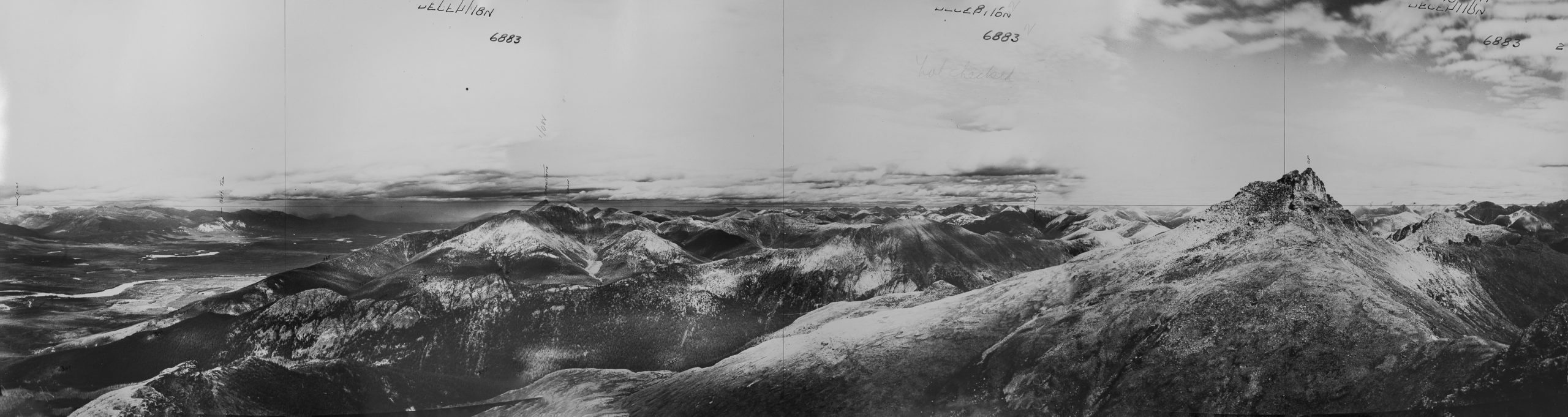
Looking north-northwest from Station Deception Peak: A. J. Campbell, 1939
Station Deception Peak: A. J. Campbell, 1939. The view looks north- northwest up the Finlay River. Parts of today’s Ed Bird-Estella Lakes Provincial Park can be seen on the middle left of the image.

Panorama looking north from Station Cork: A. J. Campbell, 1939
Panorama looking north from Station Cork: A. J. Campbell, 1939.
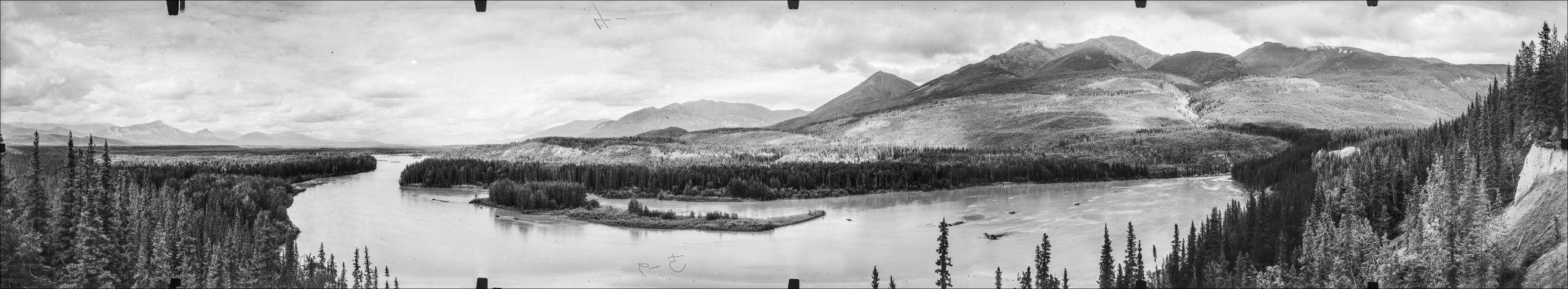
Panorama looking north from Station Cokely Post: A. J. Campbell, 1939
Panorama looking north from Station Cokely Post: A. J. Campbell, 1939. This view looks north up the Finlay River – Deserters Peak rises to the right of the image.
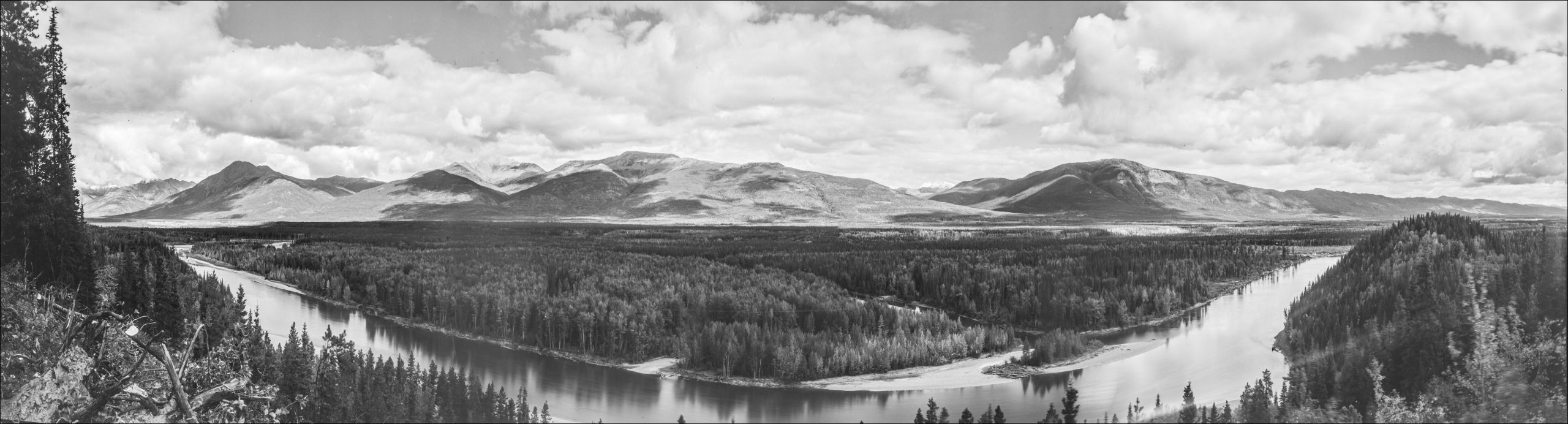
East – Northeast Panorama from Omega Station – A. J. Campbell, 1939
East – northeast Panorama from Omega Station – A. J. Campbell, 1939. The landscape shown here, which included the small Hudson’s Bay Post of Fort Graham (middle-right), is under today’s Williston Lake Reservoir..
Research Sponsors and Collaborators


