Focus on Ice and Snow
Perhaps some of the most noticeable change in the Canadian mountain west can be found in ice and snow — especially on some of the impressively large glaciers, ice fields, and snow fields that grace Canada’s heights. This gallery presents images showing change that a century or more has brought to some of Canada’s most iconic glaciers and ice fields. In all of the repeat images Mountain Legacy Project field teams work to locate the exact positions used by the historical surveyor(s) for the original images. The goal is to duplicate the historic photographs as accurately as possible. MLP teams aim to be within a metre of the historical surveyor’s camera position. The results of this careful process can be startling, revealing change that can be massive or subtle, and similarities that seem almost timeless.
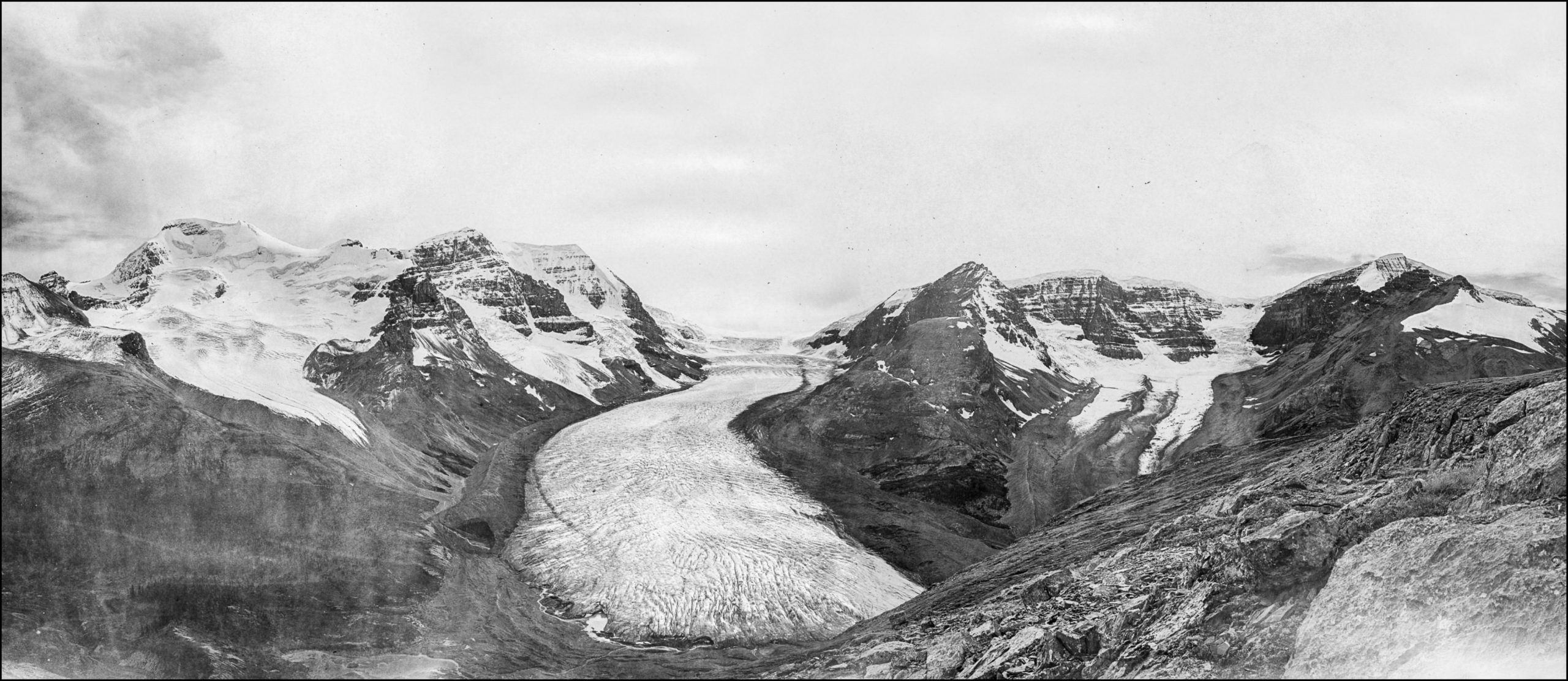
The Athabasca Glacier: A. O. Wheeler, 1917
Arthur Wheeler and his survey party are just below Wilcox peak in Jasper National Park. Visit this location online at Explore MLP for more details and images.
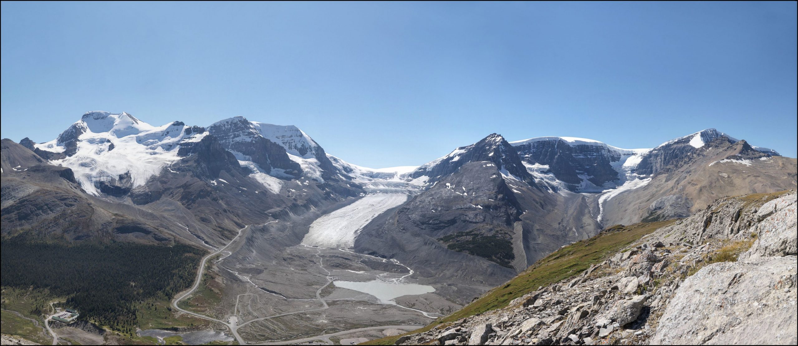
The Athabasca Glacier: MLP, 2011
The Mountain Legacy field crew accurately located Wheeler’s 1917 position and were able to get excellent matching images. Visit this location online at Explore MLP for more details and images.

Mt. Sir Donald and the Illecillewaet Glacier: A. O. Wheeler, 1901
Arthur Wheeler and his survey party are up on Abbott Ridge in Glacier National Park. Visit this location online at Explore MLP for more details and images.

Mt. Sir Donald and the Illecillewaet Glacier: MLP 2011
Not only is the Illecillewaet Glacier reduced in size in this repeat image, but other, smaller glaciers and snow fields have disappeared. Visit this location online at Explore MLP for more details and images.
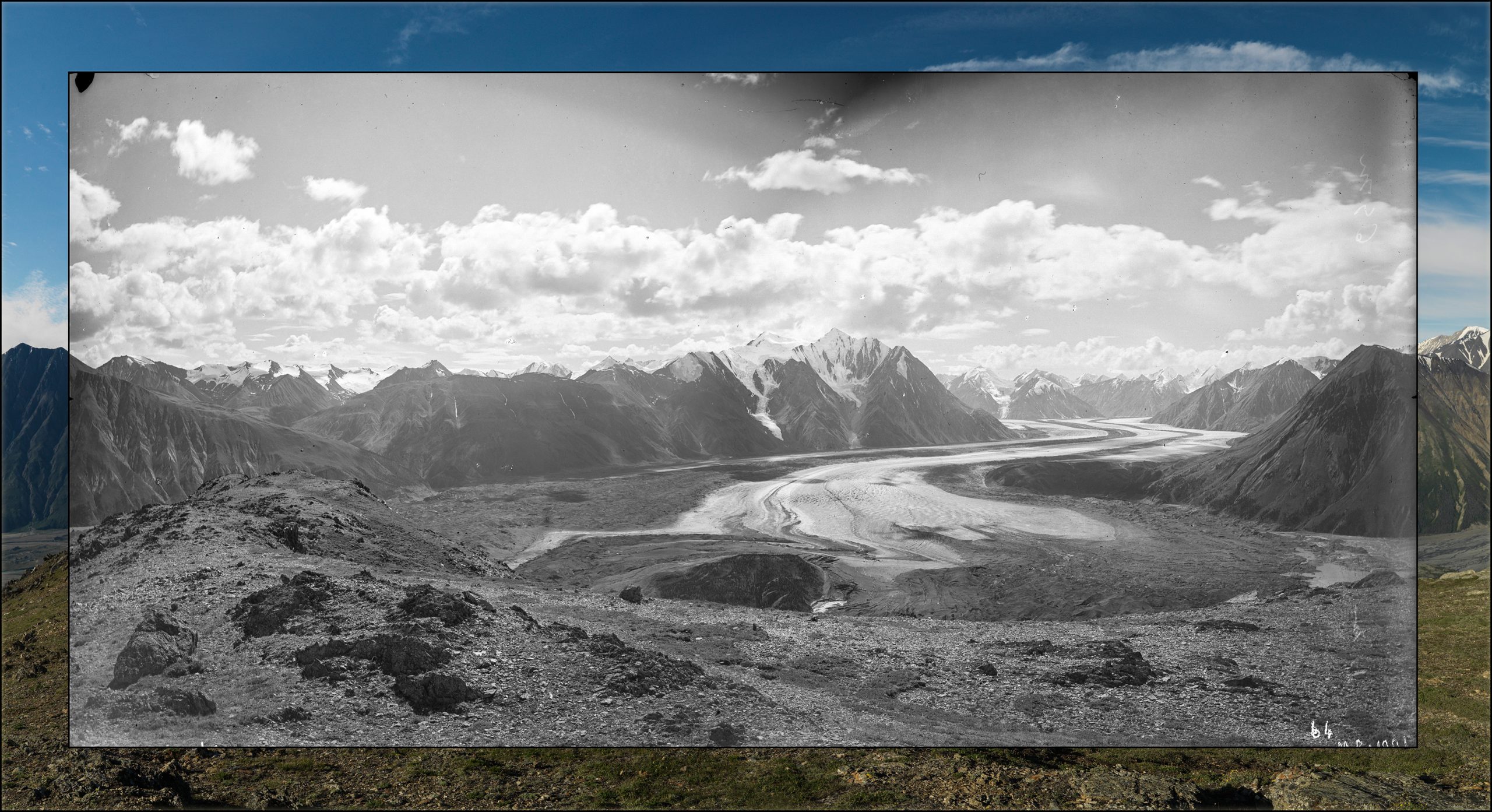
The Kaskawulsh Glacier: J. J. McArthur, 1900 (B&W inset)
In 1900 James McArthur and his survey crew were in the south west Yukon – today’s Kluane National Park – mapping the international boundary between Canada and the US. McArthur took and used photographs to help define topographic detail on his maps. Visit this location online at Explore MLP for more details and images.
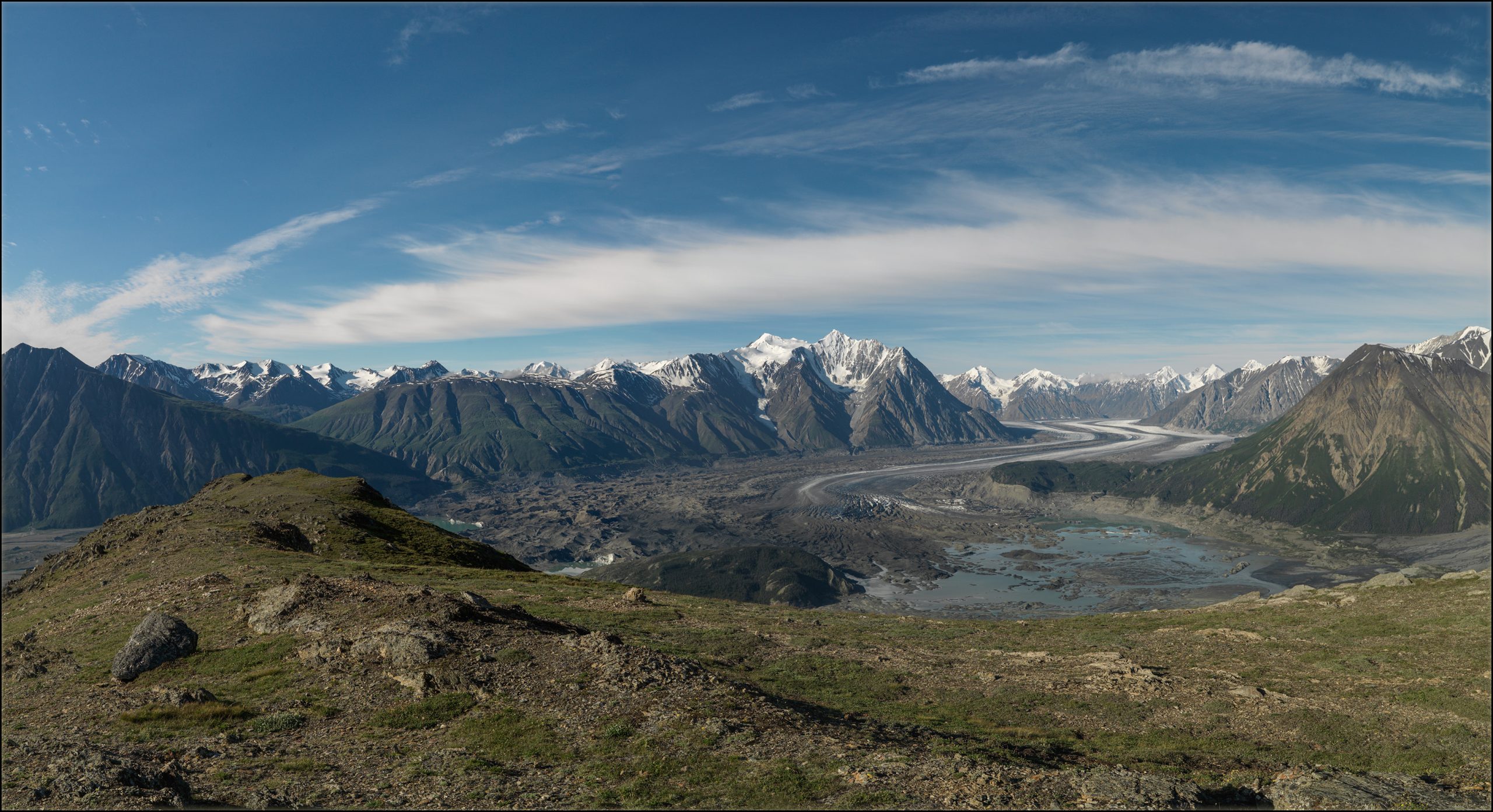
The Kaskawulsh Glacier: MLP, 2012
This glacier made the news in late 2016 when it retreated so much that its melt water changed direction. This “river piracy” has caused intense landscape change. MLP needs to return and rephotograph the repeat photos! Visit this location online at Explore MLP for more details and images.
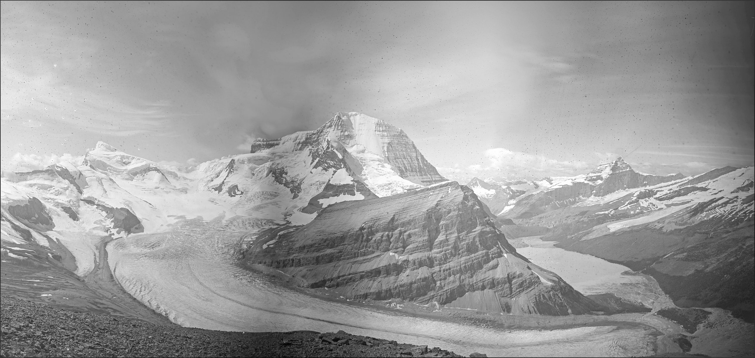
The Robson Glacier: A. O. Wheeler, 1911
Arthur Wheeler, his survey party, and a group of scientists from the Smithsonian Institution spent the summer of 1911 working in the Mt. Robson area. The images in this panorama were taken from Tatei Ridge. Mt. Robson looms above the Robson Glacier with Berg Lake to the right of the image. Visit this location online at Explore MLP for more details and images.
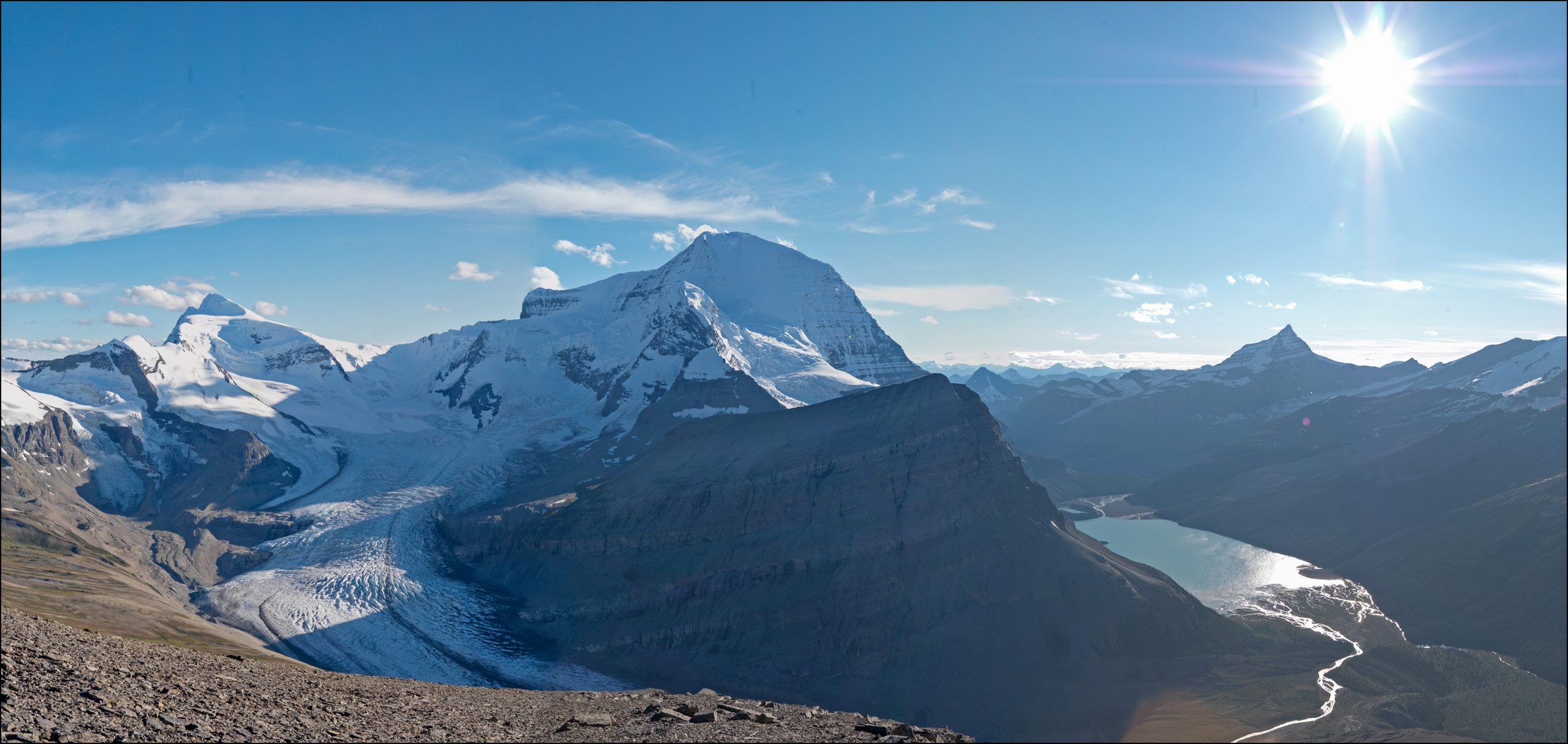
The Robson Glacier: MLP, 2011
100 years after Arthur Wheeler and the scientists from the Smithsonian visited Tatei Ridge, an MLP field team stood on the same spot and took the repeat images. Huge change in the mass of the Robson Glacier is easily observed. Visit this location online at Explore MLP for more details and images.
Mary Sanseverino
Currator of the Focus on Ice and Snow Gallery
Mary Sanseverino has been involved, in one way or another, with the Mountain Legacy Project since 2010. She has been in the field with MLP many times and continues to undertake mountain rephotography projects, often involving members of the Alpine Club of Canada as honorary MLP team members. Since 2014 Mary’s photographic interests have turned to designing and creating panoramic mountain images – the better to allow viewers to get “a feel” for the immensity of the mountain landscape. Working with images already in the MLP collection, Mary selected, created, and curated the panoramas presented in this gallery.